Commerce Geophysical Lineament CGL
Southernmost Illinois, Southeast Missouri: Scene of major earth movements in the not too distant past
The Commerce lineament is a northeast-trending magnetic and gravity feature that extends from central Arkansas to southern Illinois over a distance of ~400 km. It is parallel to the trend of the Reelfoot graben, but offset ~40 km to the northwest of the western margin of the rift floor. The age of the source of the Commerce geophysical lineament is not known, but the linearity and trend of the anomalies suggest a relationship with the Reelfoot rift.
Several earthquakes above magnitude 3 coincide with the Commerce geophysical lineament, but the diversity of associated features along the length of the Commerce geophysical lineament obscure its relation to the release of present-day strain. It is difficult to attribute individual earthquakes to a specific structural lineament such as the Commerce geophysical lineament. However, the close correspondence between Quaternary (last two million years) faulting and present-day seismicity along the Commerce geophysical lineament is intriguing and warrants further study.
--edited from abstract Geological Society of America Bulletin: Vol. 109, No. 5, pp. 580–595. Langenheim and Hildenbrand
Langenheim, V.E., and Hildenbrand,T.G., 1997, Commerce geophysical lineament--its source, geometry, and relation to the Reelfoot rift and New Madrid seismic zone, GSA Bulletin, v. 109, n. 5, p. 580-595.
Just across the Mississippi River to the east are more discoveries of faulting, near Thebes Illinois.
Geologic studies indicate that large earthquakes occurred within the southeastern Missouri region in approximately 300 AD, 900 AD, and 1400 AD. Lesser quakes of 4.6 or below have occurred in 1990, 1992, 1998 and 2003 in areas ranging from central Missouri to the far southeastern Bootheel of Missouri.
Geologists have found and mapped paleoliquefaction features that date between 22,750 and 590 years before the present in sediments located between Poplar Bluff and Dexter. This dating was based upon radiocarbon ages of the sediments bounding the structures. These features are a series of buried sandblows and associated sand dikes that resulted from four separate paleoearthquakes. These anomalies suggest earthquakes of at least moderate magnitudes occurred outside the NMSZ.
Another paleoearthquake study used geologic mapping as a guide to find a series of faults near Commerce, Mo., 20 miles north of the NMSZ. Trench mapping found evidence for five surface fault rupture events. The oldest of these events was 75,000 years, while two were within the past 5,000- 6,000 years.
http://www.dnr.mo.gov/magazine/2004-fall.pdf
Reelfoot Rift and Commerce Geophysical Lineament
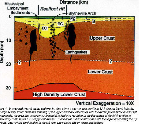
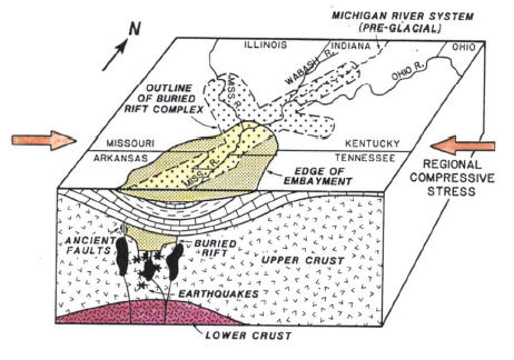
The most prominent buried structure in the Embayment is the Reelfoot Rift. The structure is a 300 km long, 70 km wide buried Late Precambrian to Cambrian failed rift structure within the Mississippi Embayment (Shedlock and Johnston, 1994; Van Arsdale, 1997). The majority of the earthquakes that occur in the central United States seem to be related to the rift and nearby igneous bodies. The Reelfoot Rift is considered to be the one of the main sources of the seismic activity that defines the New Madrid Seismic Zone (NMSZ) (Hildenbrand, et al., 1996).
The rift is part of a southwest-trending failed rift system overlain by the south-plunging Cretaceous and Tertiary sediments of the Mississippi Embayment. Figure 3.3 shows the approximate location of the Reelfoot Rift beneath the Mississippi Embayment. The Reelfoot Rift has been mapped by gravity and magnetic surveys, and exhibits 1.6 to 2.6 km of structural relief on the magnetic basement (Shedlock and Johnston, 1994). The bounding and axial faults of the rift appear to be major contributors to the seismic activity in the NMSZ (Hildenbrand, et al., 1996).
Figure 3.4 is a shaded relief magnetic map of the NMSZ, showing the Reelfoot Rift, recorded earthquakes, major igneous bodies, and the Commerce Geophysical Lineament (CGL).
The CGL is a linear magnetic anomaly that trends northeast and parallels the Reelfoot Rift (Figure 3.4). The CGL appears to be related to a series of faults that outcrop near the town of Commerce, MO. Sedimentary deposits as young as 12,000 years old have been broken by fault movement in that area (Hildenbrand, et al., 1996). The CLG is a poorly understood structure, but is believed to be part of a zone of faulting over 150 miles long, and may represent a significant seismic risk for future NMSZ earthquakes.
NEW MADRID SEISMIC ZONE
The New Madrid Seismic Zone, located within the upper Mississippi Embayment, is the most seismically-active area in the United States east of the Rocky Mountains. The extent of the NMSZ is defined by the clustered areas of high seismic activity, mainly related to the Reelfoot Rift and large igneous bodies within the upper Mississippi Embayment (Figure 3.4).
The seismic activity that defines the NMSZ generally has earthquake epicenters between 5 and 15 km deep. The area of greatest seismic activity lies mostly in Precambrian basement rocks within the Reelfoot Rift and near the large igneous intrusive bodies underlying the Mississippi Embayment. There are three major trends in the seismic activity monitored in the NMSZ since 1974.
A northeast-trending zone from Marked Tree, AR, to Caruthersville, MO exhibits right-lateral strike-slip movement which appears to be coincident with the Paleozoic Blytheville Arch. A northwest-trending zone extending from Ridgely, TN, through the Lake County uplift, and on to New Madrid, MO, follows the southwest-dipping Reelfoot reverse fault and a large igneous body (Figure 3.4). The third zone trends northeast from New Madrid. This trend appears to be caused by right-lateral strike-slip motion along one of the Reelfoot Rift´s northwest bounding faults.
We are investigating young faults just north of the New Madrid Seismic Zone in southern Illinois. Some faults near Metropolis outline narrow blocks that dropped down during the Pleistocene "ice ages". Near Olmstead, a swarm of earthquakes occurred in 1984 near what appears to be the junction of faults that run northeast and northwest.
In the Thebes area we are checking reports of faults that offset Pleistocene river sediments. Faults that have the same trend were active at or after the end of the Pleistocene, 10,000 to 15,000 years ago, just across the river in Missouri.
-- http://erp-web.er.usgs.gov/reports/annsum/vol38/cu/g2525.htm
Faults that displace Pleistocene ("ice age") sediments were studied at six sites in southernmost Illinois. The faults run north to northeast and line up directly with the New Madrid Seismic Zone. Displacements of 10 to more than 30 meters affect sediments more than 75,000 years old.
Small offsets of 1 to 2 meters were observed on units younger than 75,000 but more than 15,000 years old. Sediment younger than 15,000 years is not disturbed. Our findings suggest that although southernmost Illinois is seismically quiet today, it was the scene of major earth movements in the not too distant past.
-- http://erp-web.er.usgs.gov/reports/annsum/vol40/cu/g2525.htm
http://web.mst.edu/~rogersda/nmsz/ several Powerpoints
During the summer of 1997, the Department of Geology and Geophysics, University of Missouri-Rolla (UMR) and the Missouri Department of Natural Resources, Division of Geology and Land Survey (MoDNR), conducted a shallow reflection seismic study (9 seismic profiles; approximately lineal 12 km of data) of the Commerce Geophysical Lineament (CGL) both within and adjacent to the Benton Hills, southeast Missouri.
Our interpretations support the thesis that the Commerce Geophysical Lineament is a structurally complex fault zone and that the southeastern escarpment of the Benton Hills is tectonic in origin. Our interpretation suggests that the Commerce Geophysical Lineament constitutes is part of a late Quaternary fault system located outside of the New Madrid area of active micro-seismicity. This implies that earthquake risk in southeast Missouri is greater than generally thought
-- http://erp-web.er.usgs.gov/reports/annsum/vol40/cu/g3038.htm
Recent geophysical studies by the U. S. Geological Survey have identified a deeply buried (a mile deep or greater) feature in the ancient rocks underlying the central United States. This feature, named the Commerce Geophysical Lineament (named after the Commerce fault, which in turn is named after the town of Commerce, Missouri), was identified based on the magnetic and gravity signatures of these old rocks and is thought to represent a deep-seated weakness in the Earth's crust similar to the Reelfoot Rift that hosts the New Madrid seismic zone.
The northeast-southwest trending Commerce Geophysical Lineament passes through southeast Missouri about 30 miles to the northwest of the New Madrid seismic zone. It extends southwestward to near Little Rock, Arkansas and northeastward to central Indiana. Several studies in Missouri have associated near surface features showing geologically recent earthquake activity with the lineament.
On Crowleys Ridge in the Benton Hills of Scott County, Missouri, trenching and seismic reflection studies by the Missouri Department of Natural Resources' Geological Survey Program, the U. S. Geological Survey and the University of Missouri - Rolla have documented several sites where geologically recent fault movements have occurred.
At the intensively studied English Hill site, trenching investigations have been interpreted to show two or three periods of faulting with associated earthquakes in about the last 10,000 years. Several periods of even older fault movement have also been interpreted. Reliable data do not yet exist to estimate the magnitude of these earthquakes.
However, large fault offsets and evidence of surface rupture suggest a minimum of magnitude 5 to 6, but probably higher. Seismic reflection geophysical surveys, using reflected waves of vibrations sent into the ground to produce an image of the underground layers and faults, have confirmed that surface features found in the trenches are connected to faults deep in the bedrock, and have been repeatedly activated throughout vast amounts of geologic time.
Numerous seismic reflection surveys along the straight southeast flank of the Benton Hills have shown intense faulting above the trace of the Commerce Geophysical Lineament, suggesting a relationship between the lineament, the intermediate depth faulting and the surface faulting.
Many of the imaged faults show displacement of the youngest geologic materials observable. The town of Commerce, located on the Mississippi River at the south edge of the Benton Hills, is the site of the Commerce fault and is close to three other sites where young faulting has been documented.
The largest earthquake in Missouri in the last 10 years was located in the Benton Hills near the Commerce Geophysical Lineament. This was the September 26, 1990, magnitude 4.6 earthquake that happened during the Iben Browning incident.
About 40 miles to the southwest along the Commerce Geophysical Lineament is another paleoseismology site referred to as Holly Ridge. This site is located in the Bloomfield Hills, also on the southeast flank of Crowley's Ridge and directly above the lineament.
At this site, which has only had a preliminary investigation by the Missouri Department of Natural Resources' Geological Survey Program, cut bank exposures show complex multistrand faulting in very young deposits. Large fault offsets postdate the youngest geologic unit, which is less than about 10,000 to 12,000 years old.
Because of the site location on a hillside and the preliminary nature of the initial investigation, the tectonic (earthquake) origin of these faults has not yet been verified. A landslide origin is also a possibility. However, a seismic reflection survey about 1.5 miles to the northeast along the lineament trend shows tectonic faults in the youngest imaged deposit, which lends support to the argument for a tectonic origin.
Ranging from about 20 to 30 miles farther to the southwest along the Commerce Geophysical Lineament are several paleoliquefaction sites that can not be attributed to New Madrid seismic zone earthquakes. At the southern end of this range, near the town of Qulin and the Missouri-Arkansas border, another seismic reflection survey has shown faulting above the lineament in the youngest deposits imaged.
In Arkansas along the Black River, additional young paleoliquefaction sites have been found above the lineament. In 1982, a swarm of hundreds of small earthquakes occurred near Enola, Arkansas, which is also near the lineament.
The largest earthquake in the central United States this century, a magnitude 5.5 quake, occurred on November 9, 1968. It was located in southeastern Illinois near the Commerce Geophysical Lineament.
Along the Wabash River valley separating Illinois and Indiana, and along its tributaries in west central Indiana and southeastern Illinois, a large number of paleoliquefaction sites have been located and studied. These studies indicate that several large earthquakes have occurred in the last 10,000 years in that area, which is also located near the lineament.
All of this suggests the Commerce Geophysical Lineament is another earthquake source zone that needs to be considered when evaluating earthquake risk in the central United States. This has been done by the U. S. Geological Survey in preparing their latest seismic risk maps for the United States.
The lineament is closer to most Missouri cities than the New Madrid seismic zone. It is about 75% closer to Cape Girardeau and Poplar Bluff and about 25% closer to St. Louis.
A new paleoliquefaction study report by the University of Maryland that was funded and published by the U. S. Nuclear Regulatory Commission has just been released.
The study area was along the Mississippi River and its tributaries from Cairo, Illinois, to St. Louis, Missouri. Paleoliquefaction features were found in several areas including along the lower Meramec River just south of St. Louis and along the Kaskaskia River in Illinois east of St. Louis.
Preliminary age dating of the features has had only limited success resulting in poorly constrained and overlapping age ranges. Also, the liquefaction susceptibly of the sediments has not yet been evaluated in detail. This results in several possible earthquake scenarios, which could explain the current data.
These include a magnitude 7 earthquake about 40 miles east of St. Louis about 6,500 years ago or two separate earthquakes of about the same age with one being a magnitude 6 about 40 miles east of St. Louis and the other being a magnitude 5 in the south part of metropolitan St. Louis.
Earthquakes of these sizes located close to St. Louis could do much more damage in St. Louis than a much larger quake located in the more distant New Madrid seismic zone. For comparison, the November 9, 1968, magnitude 5.5 earthquake in southeastern Illinois was 100 miles from St. Louis, but even it caused some minor structural damage in St. Louis.
As a reminder that St. Louis in not immune from earthquakes, a magnitude 2.4 quake struck near Fenton on the Jefferson - St. Louis County border on January 15,1998. This earthquake was felt over a large area of south St. Louis County and northeast Jefferson County.
-- http://www.eas.slu.edu/SeismicSafety/ANNUAL.99/n05.html
The Bootheel Lineament is now (2003-2005) called the Bootheel Fault after several drillings confirmed the existence of an offset.
“A lineament is a term geologists use when they don’t know what it is,” says Arch Johnston of the University of Memphis.
http://www.eas.slu.edu/eqc/eqc_publ/flyers.html - helpful graphics
Depths
 |
 |
The focal depth of an earthquake is the depth from the Earth's surface to the region where an earthquake's energy originates (the focus). Earthquakes with focal depths from the surface to about 70 kilometers (43.5 miles) are classified as shallow. Earthquakes with focal depths from 70 to 300 kilometers (43.5 to 186 miles) are classified as intermediate. The focus of deep earthquakes may reach depths of more than 700 kilometers (435 miles).
The focuses of most earthquakes are concentrated in the crust and upper mantle. The depth to the center of the Earth's core is about 6,370 kilometers (3,960 miles), so event the deepest earthquakes originate in relatively shallow parts of the Earth's interior.
-- http://pubs.usgs.gov/gip/earthq1/earthqkgip.html