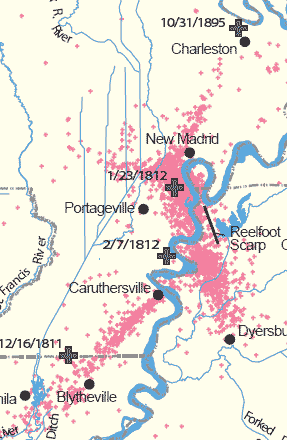
New Madrid Feb. 7, 1812 3:45 AM
The RIVER RAN BACKWARD - "retrograde current"
There were perhaps 2000 quakes over a few months in Dec 1811-Feb 1812. More scientists now believe they were in the magnitude 7 range instead of 8 ... perhaps even the low 7's.
Below is a section we lifted from what is a serious study of nearly 20 years ago - www.ceri.memphis.edu/compendium/enigma.pdf - we have added some graphics.
THE ENIGMA OF THE NEW MADRID EARTHQUAKES OF 1811-1812
Center for Earthquake Research, University of Memphis, 1996.
"we narrate what we believe happened in the winter of 1811 to 1812. This ... scenario... components range from confidently established to speculative."
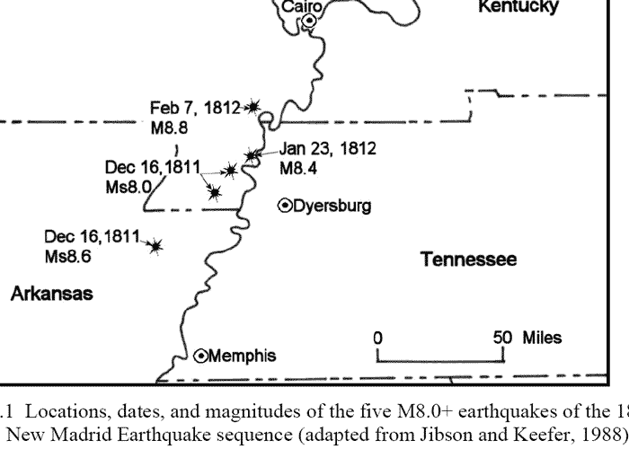
The Ohio River icejam broke up at Louisville falls about the time of
(January) event JI [Nolte (1854) reports that earthquakes "loosened the ice"],
and many boats that began the trip to New Orleans at the falls had reached New
Madrid and tied up for the night of 6 February 1812 ( Island 9, just below the "e" in
"New" on small map just below).
 At
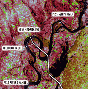
03:45 on 7 February the main dip-slip event of the entire sequence nucleated on
the RF thrust fault plane in the left stepover that splays to the surface as
Reelfoot scarp. The rupture was not contained by the RF, however, and continued
onto the preexisting New Madrid west (NW) fault segment as a left-lateral
strike-slip rupture.
At
03:45 on 7 February the main dip-slip event of the entire sequence nucleated on
the RF thrust fault plane in the left stepover that splays to the surface as
Reelfoot scarp. The rupture was not contained by the RF, however, and continued
onto the preexisting New Madrid west (NW) fault segment as a left-lateral
strike-slip rupture.
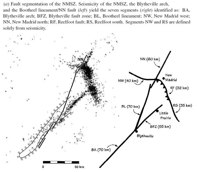
The NW segment developed perhaps as a deflection of the RF thrust around the
dense, rigid Bloomfield pluton. Major aftershocks would extend the RF rupture to
the southeast on the Reelfoot south (RS) segment, a separate, more steeply
dipping fault plane. The
 FI
sequence released the final third of the seismic strain energy available to
drive the 1811-1812 earthquakes. The M 8.0 mainshock was probably a complex
multiple event with both dip-slip and strikeslip subevents, averaging perhaps as
much as 10 m displacement.
FI
sequence released the final third of the seismic strain energy available to
drive the 1811-1812 earthquakes. The M 8.0 mainshock was probably a complex
multiple event with both dip-slip and strikeslip subevents, averaging perhaps as
much as 10 m displacement.
The RF thrust subevent of the F1 mainshock created one waterfall or rapids and
two flow barriers on the Mississippi River's Kentucky bend; an additional falls
may have formed on the bend's western limb by deformation in the hanging wall.
The hanging wall of RF rose beneath the river during F1 from ~12 km to ~17 km
upstream of New Madrid. This created an uplift that obstructed flow near island
#10 and a downdrop falls or rapids downstream of the island. This combination
was the most severe river disruption; it generated the great upstream wave and
retrograde current so graphically described by Speed (1812) and the "patron" (Shatler
1815).
Both travelers' flatboats would survive being swept over the downstream falls.
The second intersection of RF with the river was immediately downstream of the
town New Madrid (within 1 km). It uplifted the riverbed by one-to-several
meters, accounting for the large wave and retrograde current at New Madrid,
independently described by
Bryan (1848) and Nolte (1854).
The riverbed from New Madrid to island #10 and the lakebed of to-be-formed
Reelfoot Lake were on the footwall of a great thrust earthquake. Elastic rebound
then accounts for their permanent subsidence by several meters relative to their
pre-earthquake levels. Similarly, Reelfoot scarp's hanging wall was permanently
uplifted. This combination of subsidence and uplift accelerated the town's
takeover by the river and created the new lake.
 |
 above: from Columbus Ky park
|

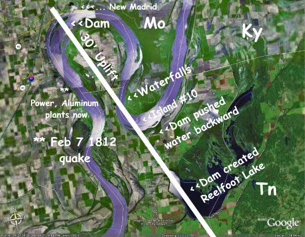
Above: the uplift pushed NE. This is oversimplified.
http://nmfault.weebly.com/ran-backward.html <<< RIVER RAN BACKWARD