Ohio River course changes | Glaciers
|
 |
 |
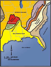
Probably during Cretaceous time, the bedrock of the Pulaski area was raised and tilted toward the northeast by the uplift of the Pascola Arch, which was centered in the "bootheel" area of Missouri. These rocks dip gently northeast, away from the Pascola Arch and toward the Illinois Basin.
The sea withdrew from the region, and the bedrock was deeply eroded, leaving Devonian rocks exposed at the surface in the southwestern part of the quadrangle, and Mississippian rocks in the northeastern part, during the Cretaceous period.
Olmsted fault
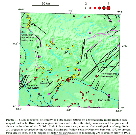
To the immediate east northeast is the Cypress quadrangle. Of interest is the Cache River valley (see below on this page) and Olmsted fault which [partially] connects the New Madrid area to the Wabash Valley of Southern Indiana. Read more, see several maps.
Pulaski, Cache River, Olive Branch, Horseshoe Lake, Commerce, Cairo area map
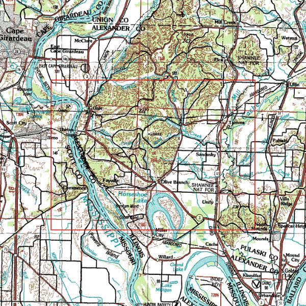
Pulaski is at mid-right of map. Cache River runs near Ullin and Tamms. The Old Ohio river bed continued past Olive Branch, Horseshoe Lake, to Commerce MO then southward. "English Hills" are just northwest of Commerce.
The Mississippi Embayment came into this area, perhaps as high as Ullin and Wetaug (top right of map).
Topographic map - pdf, from UIUC, of Dongola, Ullin, Cache river valley, description of several soils, timeline
The Mississippi River did not have the "Thebes gap" between Thebes and Commerce until 10-15,000 years ago, when significant quakes shook the Commerce Lineament.
topography of the region | origins
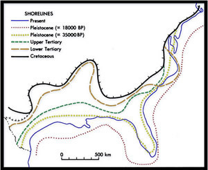
These bedrock exposures subsequently were covered by younger sediments. During the late Cretaceous Period, about 70 to 80 million years ago, the region that is now the lower Mississippi Valley was downwarped into a deep trough, open to the south. This trough, known as the Mississippi Embayment, became a northeast-trending arm of the Gulf of Mexico, extending into southernmost Illinois.
The Cretaceous Post Creek and other formations were deposited in bays, deltas, and tidal flats bordering the Embayment seaway. Following deposition of the Wilcox about 50 million years ago, the sea again withdrew from southern Illinois and erosion resumed.
The next episode of sedimentation took place late in Tertiary time (roughly 2 to 10 million years ago) when big rivers, related to the ancestral Mississippi and Tennessee Rivers, coursed across the lowlands of the northern Mississippi Embayment. These rivers deposited coarse red and brown sand and gravel now known as the Mounds Gravel.
The flood plain was then eroded to approximately the 400-foot elevation contour of today, such that in most of the map area the Mounds Gravel is found at or above 400 feet above sea level. Toward the end of this episode, the ancestral Tennessee River eroded a broad valley near the modern Ohio River from Paducah, Kentucky to Cairo, Illinois; and passing through the southeast corner of the Pulaski Quadrangle.
Mounds Gravel was deposited upon the floor of this valley. Then the ancestral Tennessee apparently shifted, leaving only small, meandering creeks within its older valley.
While these events were taking place, the Ohio River was flowing far north of its present course through the Teays-Mahomet bedrock valley in east-central Illinois.
When Pleistocene continental glaciers advanced across central Illinois, the Teays-Mahomet Valley was buried in glacial drift and the Ohio had to seek a southern route. [diagram] Its new course lay close to the modern one, but in southern Illinois the Ohio carved out a deep and wide valley now known as the Cache Valley. Photo is near Perks IL.
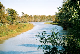
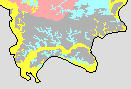
The Cache River flows near Perks and Ullin Illinois through a former Ohio River bed. Shown in yellow in lower image.
The Cache River drains most of four counties in Southern Illinois -- Alexander, Union, Johnson and Pulaski. The swamps are the northernmost cypress wetlands in the Mississippi River delta region, and numerous plants, insects and animals are found only in those swamps.
Efforts to preserve the Cache River from development took root in the late 1960s and early 1970s as a coalition was formed to prevent the draining of the swamps.
The Cache River is a rare location because it drains one of the few areas in Illinois that was not covered with glaciers during the last ice age. The Shawnee Hills, the Ozark Plateau, the Mississippi Delta and the Central U.S. Plains meet along the Cache drainage area.
An SIU-C study of the direct economic impact of the public wildlife refuges and nature areas found that visitors and employees provide $3.6 million in direct economic impact, creating 86 permanent jobs.
Steve Gough, a scientist who studies how land changes over time, (www.emriver.com, Murphysboro, IL) offers a theory of how some sections of the Cache were formed. Many of the cypress trees in the swamps are about 1,000 years old. And in some places, the Cache is far deeper than would otherwise be expected in a slow-moving, swampy river system.
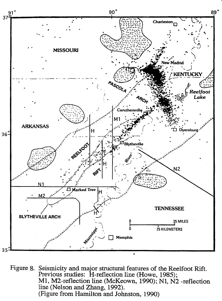
Part of the Cache flows through an old channel of the Ohio River, which changed course several times as the last ice age was ending, Gough said in an interview. But that still doesn't explain the depth of some areas, he said. The most likely explanation, he said, is that a large section under the Cache sank during a major earthquake about 900 A.D. The New Madrid Fault runs under the region.
The section Gough studied runs from near Karnak, Ill., to around Ullin, Ill.
"It just didn't fit in with the rest," Gough said. "It is like a big pothole in the road. It should have filled in."
-- http://medialab.semissourian.com/story/1163694.html
Flooded periodically by glacial meltwater, the Ohio deposited thick sand and gravel (Pearl and Henry Formations) within the main Cache Valley, and finer silt and clay (Equality Formation) in lowlands bordering the main valley. It was not until near the end of the last ice age, about 8,000 to 12,000 years ago, that the Ohio River abandoned the Cache Valley for its present course (Masters and Reinertsen, 1987; Esling et al., 1989).
Following each episode of glacial retreat and melt-off during the Pleistocene, the wind carried vast quantities of dust from the exposed river bottom lands across the entire Midwestern region. This wind-blown silt now constitutes the loess that blankets uplands of the Pulaski Quadrangle to depths greater than 30 feet in places.
|
|
|
Earthquakes in Southern Illinois |
Powered by ShowMe-Net