Local Seashore
Dinosaurs, glaciers, earthquakes, volcanoes
|
|
.. |
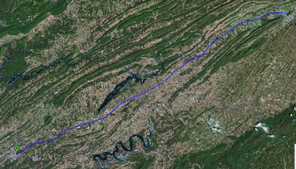
Old Ohio Riverbed, glacier
The yellow band of hills across Southern Illinois are the edge of glacier debris. You can see picturesque leftover boulders at Giant City State Park, near Carbondale, Fern Clyffe State Park near Marion, the long "Goreville hill" on I-57, and the beautiful Garden of the Gods near Harrisburg, where signs say it took the glacier a few hundred years to melt. Illinois glaciation
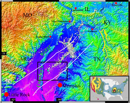
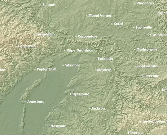
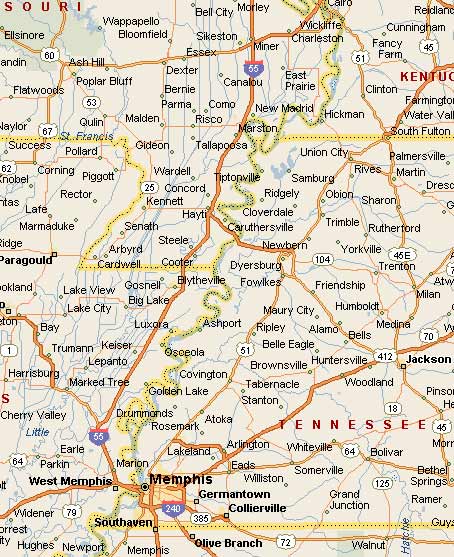
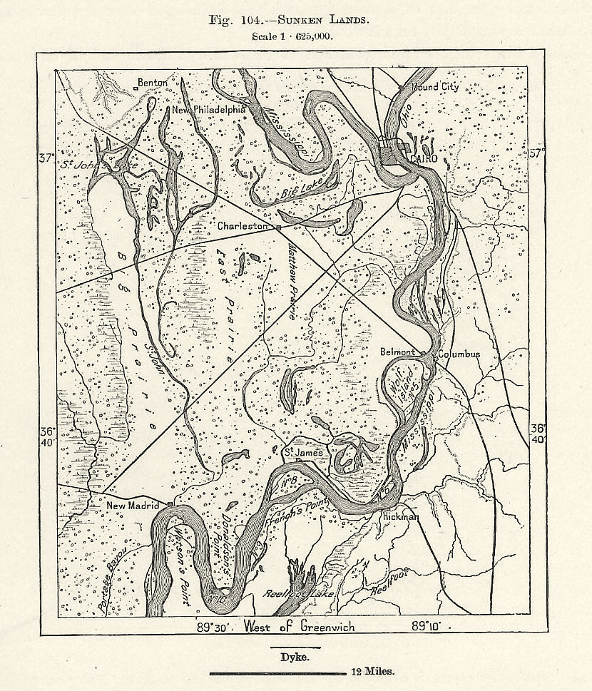
An old Ohio riverbed curved sharply westward, just south of present Golconda in SE Illinois (thin dark blue on top map, yellow on smaller map below, increasing in width westward) running a few miles south of the present Illinois Route 146. Most of the dark blue of Illinois in upper map is the present Cache River Basin and Natural Area.
news | news | nature.org | wikipedia
The old river bed continued near Olive Branch IL, Commerce MO, along ridges near Benton and Morley, MO, then south through flatland into Arkansas.
The darker blue (top map) of the old Mississippi River bed curves sharply west at the regional airport between present Scott City and Cape Girardeau.
Old Mississippi River paths; draining the swamp
The sharp westward turn of the Mississippi just south of Cape Girardeau handled the melting runoff of North America's ice ages. The Western Lowlands on the west side of Crowley's Ridge near Advance and Poplar Bluff handled the earlier Illinoian ice age melting, leaving us the Mingo Swamp and wildlife area. The later Wisconsin ice age runoff went mostly on the eastern side of the ridge. | Mingo | Crowley's
- Draining the larger swamp - in Southeast Missouri - in the early 20th century is a separate story.
- See numerous north-south ditches on the map. more In the southern bootheel, five drainage ditches run alongside each other as they drain into Big Lake, a large shallow swampy lake formed in 1811.
- For current efforts to curb river flooding between Cairo and East Prairie, search St. John's Bayou-New Madrid Floodway Project. Shaping the river today
- 1200 px 1892 map of Crowley's Ridge.
- A simpler map of SE Missouri before draining the swamp.
- 2007 Story of the Little River Drainage District (LRDD)
- 2004 Story of Little River Drainage District
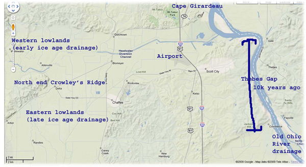
- Map of Oran-Bell city gap (eastern lowlands), western lowlands, Thebes gap
The Eastern Lowlands beginning near the community of Delta, include the "Bell City-Oran Gap" (both towns are on current maps) on the east side of Crowley's Ridge. The layered rock outcroppings on the low hills near Chaffee and Oran appear smooth and pitted.  [ref.] It doesn't take much imagination for an observer to see this was once a wide, shallow river bottom.
The Ohio River may have even joined the Mississippi at Morley, between Benton and Sikeston, for a time.
See the green strip on the map at left, southwest of the current confluence of the two rivers. This is the Crowley's Ridge separation between the eastern and western lowlands.
The glacier runoff deposited much sand and light dusty soil in these areas. The rivers eroded some of this sandy alluvium and formed a newer and lower flood plain in a portion of the valleys. The older and higher flood-plain surfaces that have been left are terraces.
The four glacial stages, Nebraskan, Kansan, Illinoian, and Wisconsinan, are named for their most southerly advances. The Wisconsinan stage covered much of the northern United States from the Atlantic coast to the Rocky Mountains as recently as 12,000 years ago.
The National Park Service says
| About 18,000 years ago a continental glacier covered North America. This continental glaciation event, with its gradual melting period from 12,000 to 7,500 years ago, was the last in a series of continental glaciers that have formed and then receded over the last 25 million years. As the glaciers melted and reformed, the Mississippi and its tributaries carved valleys and created floodplains across the region. --nps.gov |
Global warming??? Bosh and poppycock. It's only temporary.
Swamps and marine life covered much of Illinois, south of the Quad cities to Mt. Vernon (during the Pennsylvanian age).
Thebes gap - a latecomer
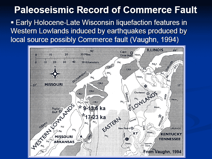
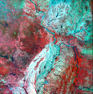
Some geologists believe the heavy seismic activity along the Commerce Lineament, about 10,000 years ago helped the Mississippi River cut through the "Thebes gap" (about 12 miles, between Thebes IL and Commerce MO) and make a new confluence at Cairo, IL. It then switched from a braided river to the meandering river through rock cuts that forms the state boundaries today. Here's an infrared view | another.
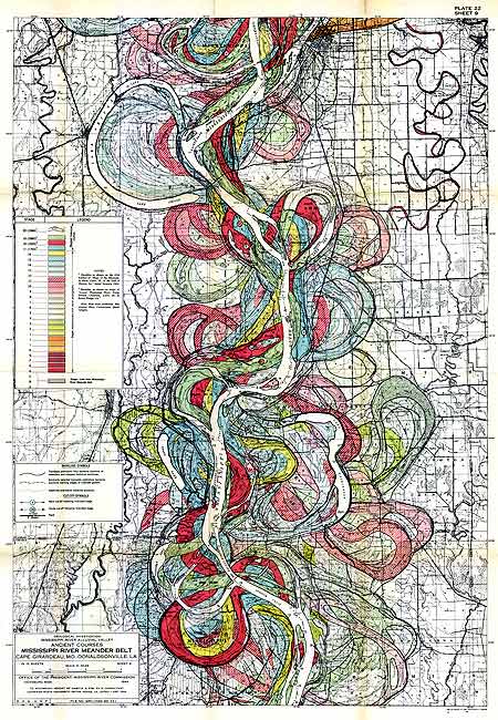
The Mississippi in older days migrated rapidly by eroding on the outside of a river bend and depositing point bars on the inside of the river bend. Abundant oxbow lakes mark old positions of the channel that have been abandoned.
Native Americans liked to settle along these oxbow lakes because the fishing, hunting and water supply was good, but the threat of flooding was less than along the river.
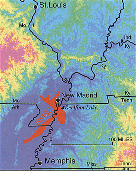
Researcher Margaret Guccione with the University of Arkansas finds the Mississippi's path changed significantly at the time of the AD 1450-1470 New Madrid earthquake.
The land at Reelfoot appears to have risen four meters in 1,000 years - quickly in geologic time. Only part of that can be accounted for in the 1811-12 quakes, she said. The rise, along with sinking of some land, blocked the flow of a creek to create Reelfoot Lake.
-
Geological Society of America Bulletin Volume: 112 Issue: 2 Pages: 221-235
-
Saucier, Roger T., 1994, Geomorphology and Quaternary Geologic History of the Lower Mississippi Valley. Mississippi River Valley Commission, U. S. Army Corps of Engineers, Vicksburg, Mississippi.
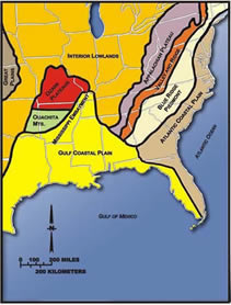
Mississippi Embayment
 |
Sediment layers, Memphis aquafer, Reelfoot Rift
Writing in the January 2007 issue of Scientific American, Roy B. Van Arsdale and Randel Cox of the University of Memphis offered the following explanation of the embayment's complex origin.
As Pangaea began to break up about 95 million years ago, North America passed over a volcanic "hot spot" in the earth's mantle (specifically, the Bermuda hot spot) that was undergoing a period of intense activity. The upwelling of magma from the hot spot forced the further uplift to a height of perhaps 2-3 km of part of the Appalachian-Ouachita range, forming an arch. The uplifted land quickly eroded and, as North America moved away from the hot spot and as the hot spot's activity declined, the crust beneath the embayment region cooled, contracted and subsided to a depth of 2.6 km, forming a trough that was flooded by the Gulf of Mexico. As sea levels dropped, the Mississippi and other rivers extended their courses into the embayment, which gradually became filled with sediment. -- answers.com/topic/mississippi-embayment/
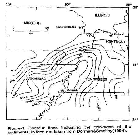
(Below) Contour lines show where a shallow Gulf of Mexico once covered the lower Mississippi Valley to Dexter, MO, and just above the junction of the Ohio and Mississippi Rivers at Cairo, IL. (See a great explanation.) Its sandy sediment deposits make the ground even shakier in earthquake territory. It was called the Mississippi Embayment Synclinorium.
 |
 |
http://www.csc.noaa.gov/beachnourishment/html/geo/
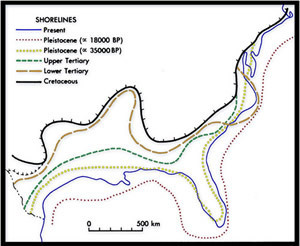
Until approximately 20,000 years ago, when glaciers were at their maximum extent, sea level was some 125 meters below its current level, and nearly all of the present-day continental shelf was exposed.
Above: Swirls in the mud? Sort of. Point A is Sikeston, MO. B is Memphis. Appalachians are at mid right. Dark streaks to the right of A are Kentucky and Barkley lakes, and Land Between the Lakes. See the "finger" shape of the Mississippi Embayment
Below: Texture of old barnwood? Point A is Knoxville, TN. Point B is Kingsport. White spots in lower right are clouds. The lines are the Appalachian Mountains, with some Smokies and Blue Ridge thrown in. They were formed when Africa pushed toward the Eastern US, way way back.
Click above for larger
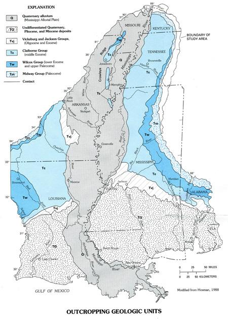
Wikipedia map of embayment, Crowley's Ridge
The current sedimentary basin results from the filling of a Cretaceous tectonic basin and existed as a large bay in the Cretaceous through early Tertiary shoreline. --Wikipedia
USGS topography map of region near Cairo IL. See other satellite topography maps lower on this page.
Old paths, meanderings of Mississippi River over the centuries. (Makes nice artwork!) This comes from the Corps of Engineers... section from Cape Girardeau Mo, southward.
An artist who made pictures with sand and glue, told us he found 25 different colors of naturally occurring sand just in Stoddard County, (Dexter) MO at the north edge of the Bootheel. He believes the sand colors were formed when this landlocked area was a seashore.
A MO Department of Natural Resources person told us the underground water table in the Bootheel is sloped such that people in the southern Bootheel are now pumping water from their deep wells and community water systems that fell as rain, a million years ago, just north of the Bootheel.
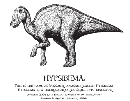
Southeast Missouri Dinosaur
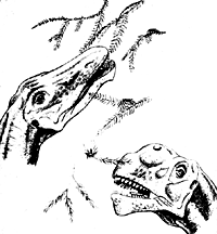 The town of Marble Hill, in Bollinger County, half an hour west of Cape Girardeau, has dinosaur remnants that were trapped in a seismic fault south of town. Townspeople have opened a Natural History Museum. It's the only dinosaur found for many hundred miles. The duck-billed Hypsibema crassicauda probably weighed two tons, was 10 feet tall, ate plants, and lived 100 million years ago. News story.
Fossils of two and possibly three other types of dinosaurs were found at the site. One of these is a relative of Tyrannosaurus rex,
Read about the Cretaceous period | Southern Illinois dinosaurs?
Missouri's dinosaur was part of the Hadrosaur family.
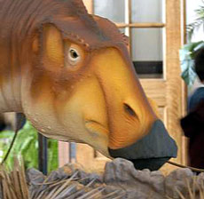 Model, at Marble Hill museum
photo courtesy SE Missourian
Bollinger County Museum of Natural History
 207 Mayfield Drive Marble Hill, Missouri 63764
573.238.1174 www.bcmnh.org
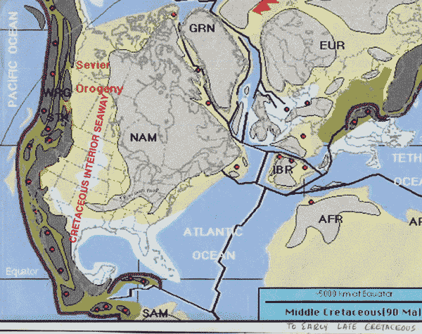
Note in map below - the grey streak across southern Illinois and southeast Missouri of Middle Cretaceous times, which are places where dinosaur bones might be found. Also note the yellow of the Great Plains, which at that time was a great ocean.
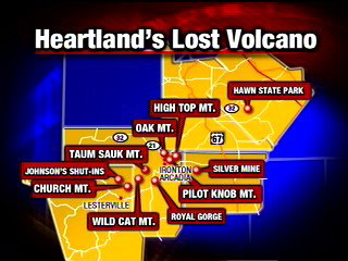
Volcanoes
One and a half billion years ago, hot volcanic ash and gases spewed into the air, then cooled, forming igneous rock. Later, shallow seas covered the rock, depositing sedimentary rock. The land rose. The sea fell.
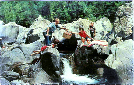
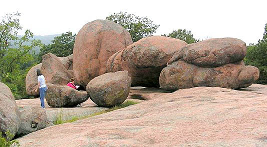
It created Johnson's Shut-Ins, near Ironton, Farmington, southwest of St. Louis, ... and Elephant Rocks (lower picture), nearby.
|
|
KFVS 2007 look at old volcano in SE MO's Mineral Area says it was probably centered at Taum Sauk mountain.
Mastodons-Mammoths
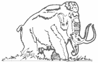 Mastodons & Mammoths, were trapped in a (then) swampy area just south of St. Louis near Imperial. They were 8-10 feet tall, but were NOT dinosaurs. The may have crossed from Alaska's Bering Strait and were here 30,000 to 10,000 years ago - the end of the ice age. Some of them probably co-existed with man, who may have arrived here 12,000 years ago.
Tropical Rainforest in Central Illinois, under the glaciers?
Some unusual species of plants in an old rainforest floor, trapped by an earthquake.
Powered by Show-Me.net