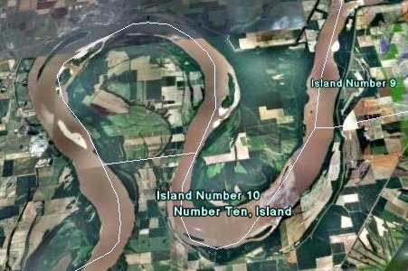
A
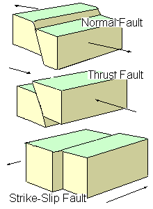
"thrust fault" uplift dammed the Mississippi for a few hours early on the morning of Feb. 7, 1812 from about Island #10 north past island #9. Ice breaking up on the Ohio River had just allowed several boats to make it to the region the day before. Multiple eyewitness stories came from those moored near Island #9, rudely awakened after 2
a.m.,
and found their boat going upstream "at the speed of a fast horse" -- "had to
hold my hat on" -- while trees continued collapsing into the river. The air
smelled of sulfur and was filled with coal dust.
There were temporary river waterfalls where the Mississippi ran backwards during 1811-12 earthquakes. It happened when a thrust fault created a sudden dam several feet high
near the bottom of the river loop near New Madrid.
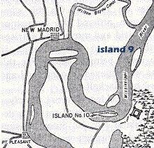
The main section involved was from island 10 northward about 10 miles to island 8. It lasted for a few hours, though the new dams/waterfalls lasted for a few DAYS, and ruined several flatboats. For an authoritative source, see the CERI Enigma paper (link below).
red=lift
blue=drop
~30 feet
Feb 7 1812
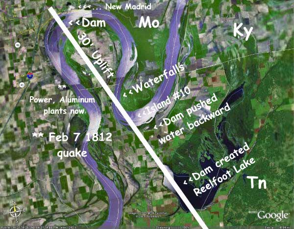
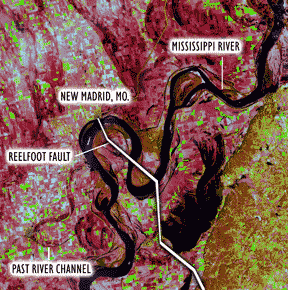
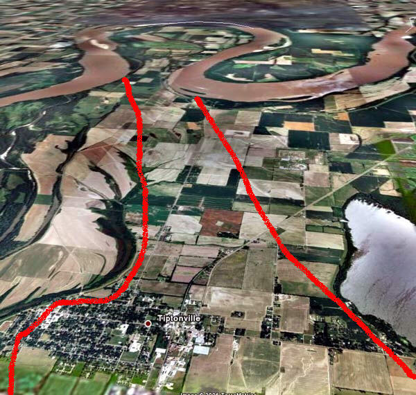
See above left the Reelfoot fault crosses the Mississippi three times (just above the red "Reelfoot scarp"). The uplift caused both a dam and waterfalls at different locations. [The Reelfoot Scarp is listed in the enigma paper as being raised eight meters (26 feet). Some listings say 10 meters (33 feet).] Many researchers now put the 1811-12 magnitudes in the 7 range instead of 8's, because they use a newer intensity scale.
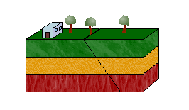
Also note how the scarp uplift dammed a creek and created Reelfoot lake, just east, on Feb 7, 1812. This pressure came from a southwest-dipping reverse fault (see thrust fault at left). Earlier shakes, further south, had come from the sideways motion of a strike-slip fault (3rd illustration at left).
The damming of the Mississippi River temporarily made the water run backward for a few hours. details | eyewitnesses | illustration
It "created one waterfall or rapids and two flow barriers on the Mississippi River's Kentucky bend; an additional falls may have formed on the bend's western limb [about 7 miles downstream from New Madrid] by deformation in the hanging wall" [Enigma].
The hanging wall upstream of New Madrid created an uplift that obstructed flow near island #10 (in bottom of loop, just above Reelfoot scarp) and a downdrop falls or rapids downstream of the island. It generated the great upstream wave and retrograde current.
Really?
Some sources try to say the river didn't really run backward, but just seemed to, as it spread out over surrounding land, after Mother Nature dropped dams across it. The most authoritative source is probably the Enigma paper, and eyewitness accounts from it and and others, which mention a "great upstream wave and retrograde current". Ask the boatmen who were rudely awakened in the middle of the night, and had to hold their hats on while their boat went rapidly upstream for "more than a mile," ... "four miles" ... "at the speed of a fast horse" ... "It was a current going backward" (see below).
For DAYS? From what we've read... the backward current lasted a few HOURS at most. But can you imagine what a few boatmen
saw... sudden large holes in mid-river several feet deep (perhaps 5 or 10 -- but
potentially as much as 10 meters which is 33 feet) with water spilling vertically into
them. These accounts are in the CERI Enigma paper and eyewitness accounts. It
took a few days for current to wear down the new dams and waterfalls.
Like the Falls of the Ohio?
Eyewitness Mathias Speed and perhaps others compared the falls temporarily created between Island 10 (bottom of the loop) and New Madrid with the "Falls (rapids) of the Ohio" which were a river landmark / obstacle adjacent to downtown Louisville, Ky.. A park naturalist described those falls for us:
The "Falls of the Ohio" dropped 26 feet over 2.5 miles as rapids, with lots of small drops.
The largest single drop was about 15 feet in the center of the river where a hydropower plant is now located - alongside Louisville.
Courtesy David Rumsey collection.
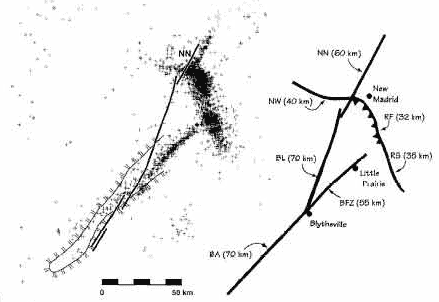
Above left: Computer generated image. Dots represent quakes below New Madrid area.
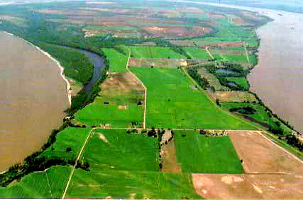
Compare the slope in the two illustrations. One side rose as much as 33 feet, damming the river at least two places, and creating waterfalls. Dot image from seismologist Roy Van Arsdale through History Channel.
This is an oversimplified diagram of the shifting during the third main (Feb 7, 1812 3:45 am) quake. Some eyewitnesses mention six to 12 foot or more vertical walls in the river for a short time before the current wore them away.
One said the reverse current pushed his boat backward four miles. Another said it was at the speed of a fast horse, and he had to hold onto his hat to keep it on. Another reported a large hole in mid-river, with water pouring into it.
See the riverbank trees in this 1938 New Madrid Ferry photo. Imagine a similar scene in 1812, pre-dawn, with trees continually falling into the river, as current runs backward and finds new places to go. Underground horrible "thunder" ... a form of lightning ... air filled with coal dust.
The Ohio River ice had broken loose, and several boats headed south had just made it to the New Madrid area the day before, which was Feb. 6th. Some boats (that went sailing rapidly backwards at 3:45 a.m.) were anchored at Island #9, halfway up the right section of river loops. Two flatboats survived being swept over falls (midsection of river loops) just downstream of Island #10 . A typical uplift in this area is as much as 10 meters (32 feet).
The next intersection of Reelfoot fault with the river was immediately downstream of the town New Madrid (within 1 km). It uplifted the riverbed by one-to-several meters [Enigma].
Large aluminum and power plants are east of Marston, very close to the 5 in top center map that denotes the largest of the 1811-12 quakes, and possibly the largest quake ever recorded in North America.
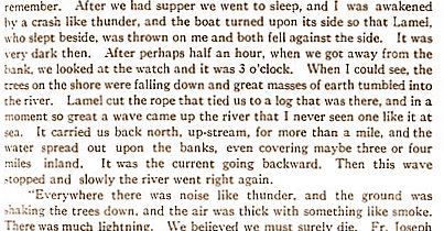
"On the evening of Nov. 15 (?), we tied up eight miles north of New Madrid near the house of my cousin... (eight miles upstream of New Madrid would have been three miles downstream from Island #10.)
"In a moment, so great a wave come up the river that I never seen one like it at sea. It carried us back north, up-stream, for more than a mile. The water spread out upon the banks -- covering three or four miles inland.
"It was the current going backward. Then this wave stopped, and slowly the river went right again.
"Everywhere there was noise like thunder. The ground was shaking the trees down. The air was thick with something like smoke. There was much lightning.
--Firmin La Roche, a French fur trader of St. Louis was taking three boats of furs to New Orleans. He scribbled this note in New Orleans Feb. 20, saying it happened in November, but the description and location seem to fit quakes in which the other boatmen reported sailing backward.
Island #10 (bottom of loop) was later famous for a Civil War battle. pic | map | more. Read how the union ironclads sneaked past rebel troops during the night, to help open the river. The battle there came a week later.
This map shows 1811-12 uplift, subsidence and submergence. Search for dip-slip and strike-slip animations.
Google Earth map above shows approximate area of uplift of "Tiptonville Dome". New Madrid is at top of river loop. Reelfoot Lake is at lower right. The uplift continues to the north as "Sikeston Ridge" see diagram.
Above is from a postcard.
Warring families:
In Mark Twain's book Life on the Mississippi, he reports on the six-decade long feud between the Darnell and Watson families and other elements of life in the Bend. "In no part of the South has the vendetta flourished more briskly, or held out longer between warring families, than in this particular region,” he wrote. Twain continues:
"There's been more than one feud around here, in old times, but
I reckon the first one was between the Darnells and the Watsons. Nobody don't
know now what the first quarrel was about, it's so long ago; the Darnells and
the Watsons don't know, if there's any of them living, which I don't think there
is. Some says it was about a horse or a cow—anyway, it was a little matter; the
money in it wasn't of no consequence—none in the world—both families was rich.
The thing could have been fixed up, easy enough; but no, that wouldn't do. Rough
words had been passed; and so, nothing but blood could fix it up after that.
That horse or cow, whichever it was, cost sixty years of killing or crippling!
Every year or so somebody was shot, on one side or the other; and as fast as one
generation was laid out, their sons took up the feud and kept it a-going.
And it's just as I say; they went on shooting each other, year
in and year out—making a kind of a religion of it, you see—till they'd done
forgot, long ago, what it was all about. Wherever a Darnell caught a Watson, or
a Watson caught a Darnell, one of 'em was going to get hurt—only question was,
which of them got the drop on the other. They'd shoot one another down, right in
the presence of the family. They didn't hunt for each other, but when they
happened to meet, they pulled and begun. Men would shoot boys, boys would shoot
men. A man shot a boy twelve years old—happened on him in the woods and didn't
give him no chance. If he had 'a' given him a chance, the boy'd 'a' shot hint.
Both families belonged to the same church (everybody around here
is religious); through all this fifty or sixty years' fuss, both tribes was
there every Sunday, to worship. They lived each side of the line, and the church
was at a landing called Compromise. Half the church and half the aisle was in
Kentucky, the other half in Tennessee. Sundays you'd see the families drive up,
all in their Sunday clothes—men, women, and children—and file up the aisle, and
set down, quiet and orderly, one lot on the Tennessee side of the church and the
other on the Kentucky side; and the men and boys would lean their guns up
against the wall, handy, and then all hands would join in with the prayer and
praise; though they say the man next the aisle didn't kneel down, along with the
rest of the family; kind of stood guard. I don't know; never was at that church
in my life; but I remember that that's what used to be said.
"Twenty or twenty-five years ago one of the feud families caught a young man of
nineteen out and killed him. Don't remember whether it was the Darnells and
Watsons, or one of the other feuds; but anyway, this young man rode up—steamboat
laying there at the time—and the first thing he saw was a whole gang of the
enemy. He jumped down behind a wood-pile, but they rode around and begun on him,
he firing back, and they galloping and cavorting and yelling and banging away
with all their might. Think he wounded a couple of them; but they closed in on
him and chased him into the river; and as he swum along down-stream, they
followed along the bank and kept on shooting at him, and when he struck shore he
was dead. Windy Marshall told me about it. He saw it. He was captain of the
boat.
"Years ago, the Darnells was so thinned out that the old man and his two sons
concluded they'd leave the country. They started to take steamboat just above
No. 10; but the Watsons got wind of it; and they arrived just as the two young
Darnells was walking up the companionway with their wives on their arms. The
fight begun then, and they never got no further—both of them killed. After that,
old Darnell got into trouble with the man that run the ferry, and the ferryman
got the worst of it—and died. But his friends shot old Darnell through and
through—filled him full of bullets, and ended him."
Life on the Mississippi, Volume 1917, Part 1 By Mark Twain p222 first printing
1874. Complete text is on books.google.com
Part of this is on a stone for the Madrid Bend Families' Cemetery
known in official registries as Whitson Cemetery -
map.
 A
"thrust fault" uplift dammed the Mississippi for a few hours early on the morning of Feb. 7, 1812 from about Island #10 north past island #9. Ice breaking up on the Ohio River had just allowed several boats to make it to the region the day before. Multiple
A
"thrust fault" uplift dammed the Mississippi for a few hours early on the morning of Feb. 7, 1812 from about Island #10 north past island #9. Ice breaking up on the Ohio River had just allowed several boats to make it to the region the day before. Multiple 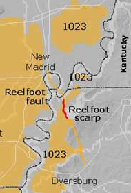

 Also note how the scarp uplift dammed a creek and created Reelfoot lake, just east, on Feb 7, 1812. This pressure came from a southwest-dipping
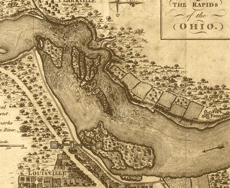