New Madrid Seismic Zone Maps

Mississippi River ran backward ??? Click here.

Map pages 1 | 2 | 3 | 4 | 5 | 6 | 7 | aerials | sitemap

Clicking a map on this website will usually take you to its source.

New Madrid and Wabash Valley seismic zones


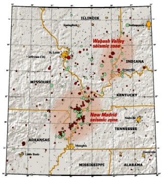
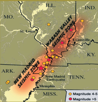
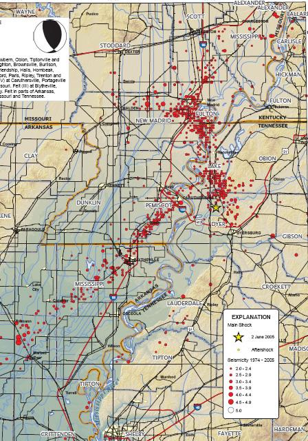
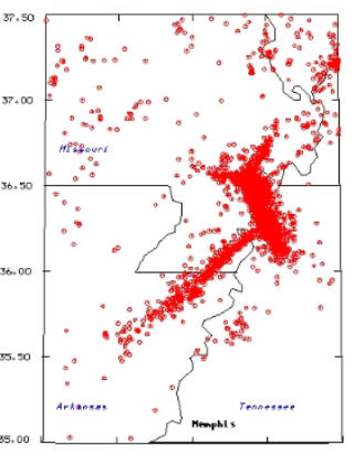
Map of the New Madrid and Wabash Valley seismic zones. Red circles indicate earthquakes that occurred from 1974 to 2002 with magnitudes larger than 2.5 (University of Memphis).

Green circles denote earthquakes that occurred prior to 1974. Larger earthquakes are represented by larger circles.

From USGS Fact Sheet 131-02, "Earthquake Hazard in the Heart of the Homeland"

Wabash Valley Seismic Zone - relation to New Madrid Seismic Zone
Indiana - Wabash fault area - Ind. Geological Survey   Illinois Basin
Left image: Indiana quakes
Right: Illinois Basin (has lots of shale oil potential) 
quakes 1800-1995
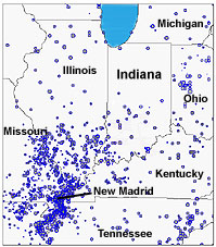
1800-1995 quakes - click map for Indiana Geological Survey site.
Wabash and NM faults map


New Madrid & Wabash Valley Seismic Zones


Meers fault in Oklahoma

Oklahoma is "riddled with faults" according to seismologist Andrew Holland. The Meers fault is the only place in the Sooner state where a fault line is visible. It's a straight line for almost 50 miles, near Lawton. Some 15 miles is clearly visible from the air. If you're in the neighborhood, visit the Meers store, with unusual storefront, specialty hamburgers and $2 ribeyes over a campfire. This place has a seismograph that is unusually sensitive to measuring quakes in the Indian Ocean, Russian missile tests, on almost the exact other side of the earth, but local US military base activity doesn't bother.


New Madrid Seismic Zone : USGS

The New Madrid fault system contains two types of faults, a strike slip segment oriented to the northeast, running from Marked Tree, AR to Caruthersville, MO, and a northwest trending reverse fault that rests below the New Madrid region. Material on the northwest side of the strike-slip fault moves northeast, and up the ramp. --St. Louis U.

from geology.com

http://geology.com/usgs/new-madrid-seismic-zone/ contains image above
http://pubs.usgs.gov/fs/2009/3071/ image original source, info of prev. quakes
http://www.emporia.edu/earthsci/student/smotherman2/globaltect2.htm Good!! Missouri geology, formation

Considerable interest has developed recently from media reports that the New Madrid seismic zone may be shutting down. These reports stem from published research using global positioning system (GPS) instruments with results of geodetic measurements of strain in the Earth’s crust. Because of a lack of measurable strain at the surface in some areas of the seismic zone over the past 14 years, arguments have been advanced that there is no buildup of stress at depth within the New Madrid seismic zone and that the zone may no longer pose a significant hazard.

As part of the consensus-building process used to develop the national seismic hazard maps, the U.S. Geological Survey convened a workshop of experts in 2006 to evaluate the latest findings in earthquake hazards in the Eastern United States. These experts considered the GPS data from New Madrid available at that time that also showed little to no ground movement at the surface. The experts did not find the GPS data to be a convincing reason to lower the assessment of earthquake hazard in the New Madrid region, especially in light of the many other types of data that are used to construct the hazard assessment.


Map pages 1 | 2 | 3 | 4 | 5 | 6 | 7 | aerials | sitemap

Blytheville area zoom - PDF

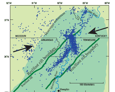
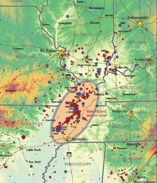
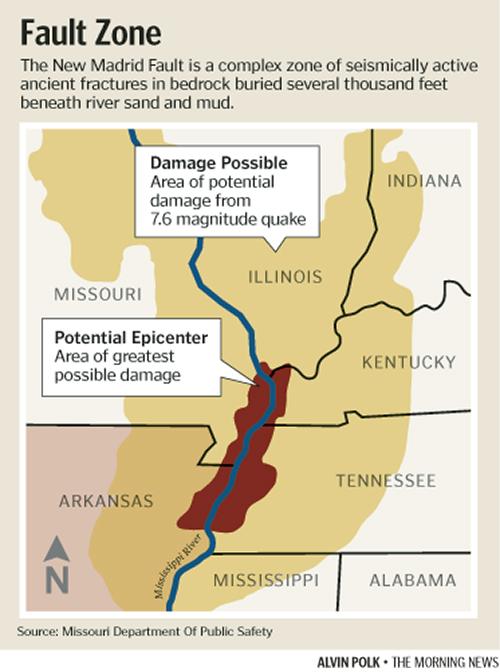
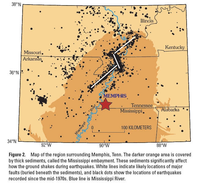
The earthquake activity roughly parallels the Reelfoot rift, an ancient break in the Earth's crust. Millions of years ago the crust began to pull apart, or rift, but failed to break completely as happens when new plate boundaries form. Instead, a long shear zone of intense faulting formed. Today the crust is being compressed in the direction shown by the arrows. Much of the seismic zone is buried beneath the Mississippi embayment (darker green area), a trough filled with sediments that may greatly amplify earthquake shaking.

http://pubs.usgs.gov/fs/fs-0007-02/fs-0007-02.pdf


landform New Madrid fault areahttp://earthquake.usgs.gov/regional/ceus/research/index.php

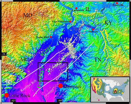
The Mississippi Embayment is shown in maps above and below. It is a finger of the Gulf of Mexico that extended to about Cairo IL for awhile. Note Crowley's Ridge above. The Mississippi River ran west of it during the first part of the ice age. An older path of the Ohio River is visible in above, just east of Cape Girardeau.

Mississippi embayment at New Madrid


New Madrid Fault quakes with lakes, roads, political lines


New Madrid area - greatest damage potential


Seismic Hazard Map New Madrid


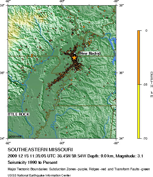
taken from a report on a Dec 18, 2009 - 3.1 magnitude event near Point Pleasant MO.

Embayment & New Madrid Fault

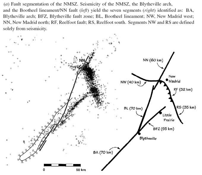
The New Madrid Seismic Zone has seven segments.

New Madrid Fault segments

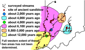
Four earlier prehistoric earthquakes or earthquake sequences have been dated
A.D. 1450 ± 150,
900 ± 100,
300 ± 200,
and 2350 B.C. ± 200 years

The two most recent prehistoric and the 2350 B.C. events were probably also earthquake sequences with approximately the same magnitude as the historic sequence.

Seven fault segments are recognized by micro seismicity and geomorphology. Surface faulting has been recognized at three of these segments, Reelfoot fault, New Madrid North fault, and Bootheel fault. Deformation at each of the fault segments does not occur during each earthquake event, indicating that earthquake sources have varied throughout the Holocene.

--Margaret Guccione, Science Direct, 2002-2005

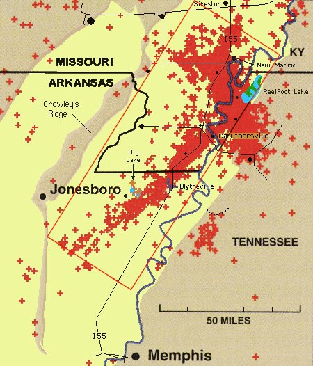
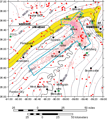
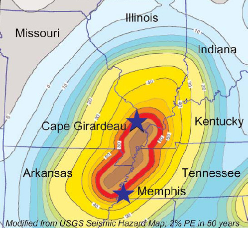
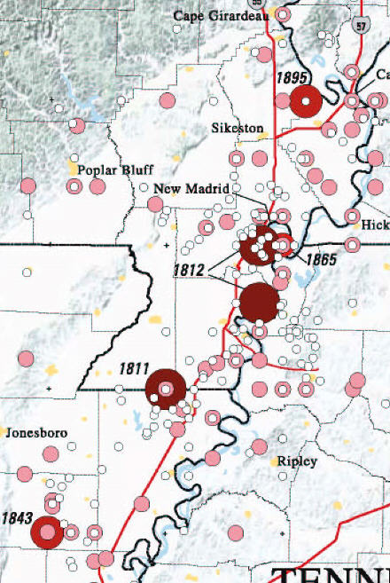
Southeast Missouri earthquake hazard map - MO DNR
all the Bootheel, confluence of Missouri and Mississippi

New Madrid Seismic Zone Maps

New Madrid fault Cottonwood Grove Nature mag

Map pages 1 | 2 | 3 | 4 | 5 | 6 | 7 | aerials | sitemap

New Madrid NMSZ seismic activity

The simplest map of the New Madrid Seismic Zone is a plot of quakes of the last few months.

USGS New Madrid seismic zone map

Deformation, liquefaction area of New Madrid region

http://www.uky.edu/KGS/geologichazards/eqinky.htm
good simple isoseismic map of eastern US from Dec. 1811 quake.

New Madrid Seismic Zone

Vast chasms, hissing sounds

An 1836 edition of The Hagerstown (MD) Mail newspaper describes the earthquakes of 1811-12. The article discusses removing obstructions from local St. Francis, White and Big Black rivers. Dr. Linn, a U.S. senator from Missouri, wrote in December, 1811 to "Hon. John Davis, chairman of a committee of the Senate." Article courtesy John Pasmore, Jonesboro, Ark.

"In the region under consideration during the continuous of so appalling a phenomenon, which commenced by distant rumbling sounds, succeeded by discharges as if a thousand pieces of artillery were suddenly exploded, the earth rocked to and fro, vast chasms opened from whence issued columns of water, sand and coal accompanied by hissing sounds, caused perhaps by the escape of pent-up steam, whilst ever and anon flashes of electricity gleamed through the troubled clouds of night rendering the darkness doubly horrible."

Pasmore offers an excellent educational DVD about the quake.

-----

Hidden Fury - The New Madrid Earthquake Zone - 27 min DVD

Hidden Fury - (click to watch) a 1993, 27-min video production, now on the web in mpg format.  Available from Bullfrog films. Very well produced. Good info, easy to follow, except several experts would now assert the NM 1811-12 quakes were high 7 magnitude, not 8. 


Quakes in Arkansas, southern section of New Madrid fault.
Map is from Arkansas Geological Survey
We're not sure all scientists agree of a huge (M7.5) quake at Marked Tree in 1811
although it is also on some USGS maps.


Map pages 1 | 2 | 3 | 4 | 5 | 6 | 7 | aerials | sitemap

Earthquake lights

Earthquake lights have been seen since ancient times. 1811-12 New Madrid quake eyewitnesses saw them possibly from as far away as Savannah GA. They were first photographed in 1968 in Japan. USGS admits their existence.

Records of earthquakes that were accompanied by sky lights can be found in 373 BC in ancient Greek writings, that "immense columns of flame" foretold the earthquake that destroyed the cities of Helike and Bura.

However, even in the early 20th century they were still considered a myth, until photographs of actual lights were taken in Japan in the 1960s.

William Leigh Pierce, a traveler on the Mississippi, observed, "On the 30th of November, 1811 about one half hour before sun-rise, two vast electrical columns shot up from the eastern horizon, until their heads reached the zenith" -- from Feldman book

>> Photograph of earthquake lights, --  more on their possible causes

>>Earthquake lightning - pseudotachylites

>>Compendium "effects" - many short quotes - nine mentions of electrical lightning-type flashes.

Could we have several minutes' warning of impending quakes by using sensors connected to a fancy voltmeter? Do electrical currents follow a seismic fault "path of least resistance"?  Geologist Eric Ferré of SIU-Carbondale IL thinks so.

Lights' appearance

The lights are most evident in the middle of the quake, although there are reports of lights that occurred after or even before the earthquake. They usually have shapes similar to those of the auroras and are white to bluish in hue, but occasionally they have been reported to have a wider color spectrum. The luminosity is typically visible for several seconds, but there have been cases in which they lasted tens of minutes.

There have been also cases in which electromagnetic waves caused by the earthquake interfered with radio transmissions, such as during the Great Chilean Earthquake of 1960. --from Wikipedia


Earthquake lights - causes

The cause of this phenomenon is unknown, but several explanations have been suggested:

* Sparks or gas ionization due to a piezoelectric effect (voltage induced by squeezing rock) in quartz-bearing rock
* Frictional heating
* Exoelectron emissions
* Sonoluminescence
* Triboluminescence - To demonstrate triboluminescence, hammer on wintergreen Life Savers in a dark room.
* Generation and ignition of flammable gases either from pockets of natural gas or from rocks under enormous stress.
* Gas ionization or electrical effects due to electro kinetics
* Separation of positive hole charge carriers that turn rocks momentarily into p-type semiconductors.  --from Wikipedia

 
New Madrid Fault is in mid-plate: USGS New Madrid shakemap 1811

New Madrid Fault is in the middle of a tectonic plate.


New Madrid Seismic shake Charleston MO 1895

Commerce Lineament exactly parallels Reelfoot Rift
see magnetic relief map further down the linked page.

New Madrid area map tiger.census.gov

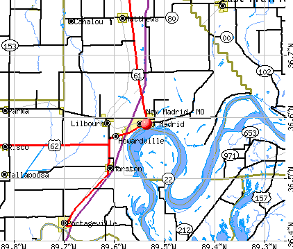
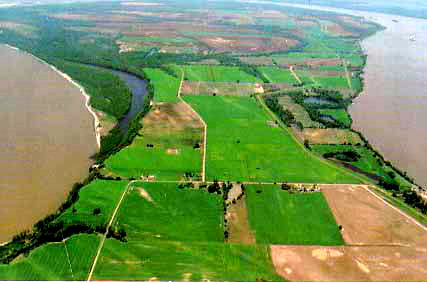
Toward the bottom of the Mississippi River's New Madrid loop, the river level is about 10 feet higher on the east (right) than on the west. The distance across the neck of the loop is just under a mile. The land is generally 30 feet higher than the river. It is called the "New Madrid Bend" "Kentucky Bend" or BubbleLand".

Mark Twain wrote of an interesting feud here. See Kentucky Bend on Wikipedia. When the river ran backward for a few hours, a waterfall was at the 3:00 position, and another dam and waterfall at the 10:00-11:00 position. Compare the route of the barbed red line of the map at left, to the photo below.

New Madrid River loop looking north.

Map pages 1 | 2 | 3 | 4 | 5 | 6 | 7 | aerials | sitemap

New Madrid Seismic Zone Maps

Simple state maps


Powered by Show-Me.net