New Madrid Fault Intro: Site map
1811-12 | Tour | Threat, outlook | Preparing | Quake lookup | Commerce lineament | Economic | Insurance | Site search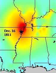 Index - Description of the largest quakes ever recorded in North America, 1811-12, and a real time map of Midwestern quakes.
Maps, pics
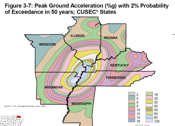
Maps - 1 | 2 | 3 | 4 | 5 | 6 | 7 (mag 7.7 scenario)
Liquefaction with many Google earth aerial photos. Sandy soil loses its friction, becomes mush with water + force.
Civil War action - big battle in the bottom of the NM river loop. Newspaper accounts & maps.
FoxNews Jan 2010 update of NM Seismic Zone following a Haiti aftershock. 6 min video
Hidden Fury (click to watch) - a 1993, 27-min video production, now on the web in mpg format. Available from Bullfrog films. Very well produced. Good info, easy to follow, except several experts would now assert the NM 1811-12 quakes were high 7 magnitude, not 8.
The following video clip is not from Hidden Fury.
Strong quakes hit Haiti in Jan 2010. FoxNews then called Gary Patterson, with CERI, Memphis, who summarized the New Madrid Fault. about 4 mins.
Origins, geography, topography
Origins - Why here, in the middle of a tectonic plate? origins2Topography - Dinosaurs, glaciers, earthquakes, volcanoes, rerouting of major rivers. Quakes played a part.
Old River beds - The Ohio River had a previous path through Southern Illinois. | Ever heard of the Teays River? | Warm shallow seas, earthquakes and glacier melt affected local soils.
- Mississippi Embayment - A warm, shallow Gulf of Mexico extended to Southern Illinois.
- Dinosaur - Southeast Missouri dinosaurs were trapped in an earthquake fault west of Cape Girardeau. Volcanoes nearby. Rainforest in central Illinois.
- The big Southeast Missouri Swamp - prior to early 20th century. Explorers Marquette & Joliet said this was the mosquitoes' home.
- Olmsted fault connects New Madrid & Wabash Valley S Indiana faults.
The Farallon plate swallowed beneath western North America 70 million years ago -- Some say it is still causing the Mississippi valley bumps and grinds.
- Farallon "hit and run" formed the Rockies?
- diagrams
- 600M years in a nutshell
Compare to California faults | S. Calif. may erupt | 99% chance
Earthquake lights
- similar to "northern lights". click here for theories of cause- Eyewitnesses saw quake lights - even in Savannah Ga
- Compendium "effects" - many short quotes - nine mentions of electrical lightning-type flashes.
Dec. 1811- Feb. 1812
"My kingdom for a horse"River ran backward - after Mother Nature suddenly dropped a couple of dams across the nation's largest waterway.
- Eyewitnesses - made notes of 1811-12 quakes
- Mississippi ran backward - from Enigma paper
- Centennial history - several notes from eyewitnesses we hadn't seen elsewhere. Note halfway through this piece that many people gathered on Tywappity hill, 30 miles north and 7 miles inland from the river... to seek safety from the shakes. We strongly suspect the hill is now at Lake Tywappity, at the SE edge of Chaffee, MO.
- First steamboat really shaken - river rerouted, island disappears
- 1811-12 quakes especially shook lowlands from near Niagra Falls to the Carolinas and lower Georgia.
- Little Prairie residents had no warning, waded eight miles. Geysers higher than trees.
Take a self-tour of the New Madrid Seismic Zone.
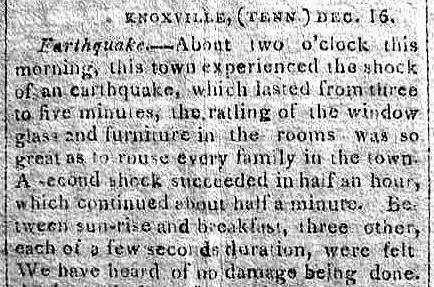
Savannah Ga - felt the big one. So did Knoxville Tn. and the Carolinas-eastern seacoast & near Buffalo NY.
SE Illinois - Carmi, White County, IL - could have been the epicenter of the Jan 23, 1812 quake. Two-mile crack, wagonloads of pure white sand, 130 air miles NE of New Madrid.
Enigma - Arch Johnston and Buddy Schweig, CERI, 1996, summarize the mysterious New Madrid Fault, and give a - part definate and part hypothetical - description of 1811-12 events.
About us - Iben Browning caused a national media circus over the New Madrid Fault in 1990. | Iben1 - AP's ode to Iben Browning.
Top of Page
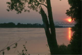
Above: Mississippi sunset
-
Worst Case
June 2007 brought a simulated big 7.7 quake. Here are damage estimates (PDF) to bridges and the river itself in case a 7.7 happened. Losses could exceed a billion dollars per county. Summary of worst case scenario per state. Regional leaders are pushing for a 4-lane bridge across the Mississippi at Helena AR, 60 miles south of Memphis. Photos of Mississippi River Bridges Top of Page
Quake Lookup
This Week - Look up recent quakes, including one just being reported.
- Midwest quake dates - past dates, locations, intensities.
- Quakes above 4.0 1811-1987
- Read the seismograph
Economic Disaster?
Contingency planning, business continuity, disaster recovery are growing topics of interest. Call cusec.org
| This website is built not to scare you, but to present accurate information. An example of MIS-information comes from Wisconsin [ Jan 08 ], saying a big NM quake would topple factory smokestacks in southern Wisconsin, but the northern part "wouldn't feel a thing." A big California or New Madrid quake will cause major economic fallout for years. The new Cape Girardeau river bridge cost $100 million and took a decade to finish. It could be the only one still usable as several others are damaged or destroyed by a major quake. Rail, air, trucking, and river distribution of goods in Memphis area is key to the nation, and will be disrupted, big-time. Remember that a "catastrophic" quake will probably be a high 7's magnitude. We're overdue for a 6+, which will likely cause some loss of life. Folks in river bottom mud will be worse off than those on the rocky hill, whether in the Missouri River valley, New York State or the eastern seaboard. (River bottom mud amplifies the shake about 6X.) We recommend you maintain a healthy faith walk with your Creator, now. Is the New Madrid seismic zone "dying"? The question likely won't be answered in your lifetime. It's dying until the next Midwest shake that's felt from Canada to New Orleans, which will start the news media asking, "Has it started again?" This site has been up for 10 years. Just before Hurricane Katrina, we were getting 35 visitors a day, and thought that was good. Just before the Wabash Valley shakes (low 5 magnitude, north of Evansville IN, Apr 08) that didn't hurt anybody, stats showed we were getting an average 250 a day. On that day it peaked at 20,000 visitors. We enjoy trying to make the info manageable and comprehendable. We consider the experts to be at CERI, Memphis, SLU-St. Louis, UIUC Champaign, and the list goes on. We appreciate feedback, positive or negative. fredkel at gmail com |
Insuring against catastrophe
Allstate insurance bows out of earthquake coverage (2006 - multiple stories). A strong New Madrid quake might cost $60 Billion.Gov. Missouri Earthquake Insurance Task Force final report Dec. 2008 | summary
| Only 35 percent of Missouri homes have earthquake insurance, down from almost 45 percent 10 years ago. The highest concentration of this coverage is in the New Madrid area of the state. Seventeen insurance companies have ceased writing earthquake coverage in Missouri since 2000; these companies insured over 83,000 homes in Missouri. In that same time period, eight new insurance companies have begun writing earthquake coverage here. |
Figures from the Mo state Department of Insurance show less than 38% of home and farm insurance policies included earthquake coverage last year. That's down more than five percentage points from 2001. During that time, the average cost of residential earthquake coverage has risen by more than 15%. Nov 2007 AP / KWMU
Church quake insurance rate once was $30 a year, now $2,500. Waynesville, MO.
Missouri & State Farm partner to make hazard map
San Fran quake insurance - most folks do withOUT.
Mo Dept of Nat Resources view of New Madrid Seismic Zone
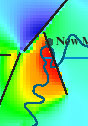
Commerce Lineament
Commerce2 - Scientists describe Commerce Lineament.
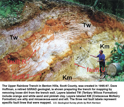
- Cross-section of the fault.
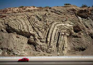
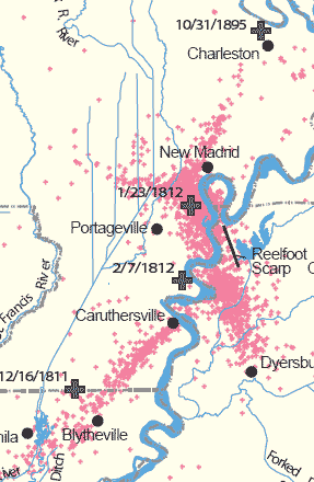
Maps, Photos of New Madrid Fault Line
Segments of NM fault - also see map links above on this pageClassroom links
books.google.com/books has 650 books about New Madrid Fault with partial or full text online.
Poster of Bardwell Ky June 2003 4.0 quake - good map of NM Fault
Overview of 1812 from NIU.edu
Assignment - Research the New Madrid Seismic Zone. Territorial Governor William Clark (of Lewis & Clark) asked the first federal emergency aid, for New Madrid quake 1811-12 victims.
Structure Damage - 300k Word doc file - Gov't report on structures damaged as far as Virginia from the three main 1811-12 quakes.
A "mini" new steel plant near Blytheville could be disrupted by a shake.
12 dancing elephants (big trucks) help map far below the ground - lithoprobe, vibroesis trucks study earthquake fault
|
|
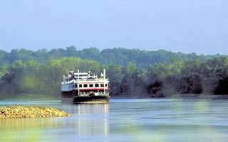
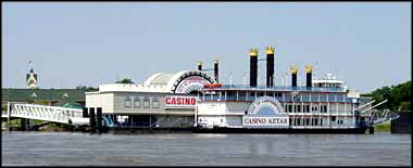
| Barges pass picturesque Columbus-Belmont (Ky) Park, on a bluff, site of a Civil War struggle. A huge anchor and section of chain at the park shows the south's attempt to close off the river during the war. (The chain broke and sank.) General Grant had little trouble cutting supplies to rebel troops, and burning a camp at Belmont, Mo., in left of picture. Most maps show the north end of the New Madrid fault about 20 miles west of this point, though some fault lines and quakes continue just north of here (in the distance of photo), through Paducah, Ky. and connect with the Wabash Valley fault near Evansville, IN. |
|
|
Top of Page
Scientific disagreement over the threat - [subsection]. Is the fault dying? Are the measurements right? |
Earthquake Prediction, quake lights
John James Auduborn saw a cloud in the west, when he was 200 miles east of New Madrid. He thought it was a brewing storm cloud. Then his horse sensed a problem. Then he saw dry land undulate like ocean waves.Several saw earthquake lights in 1811-12 even to the eastern seaboard, at the same time New Madrid was shaking, and even two weeks before the first shake. Other quake lights have been photographed in Japan. There are five theories of their cause.
Moving Continents
See origins. - "the Atlantic Ocean is growing a few inches wider each year, and the Pacific is shrinking as ocean floor is pushed beneath Pacific Rim continents" source