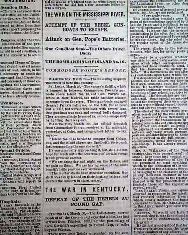
|
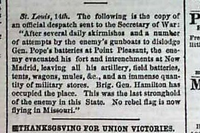
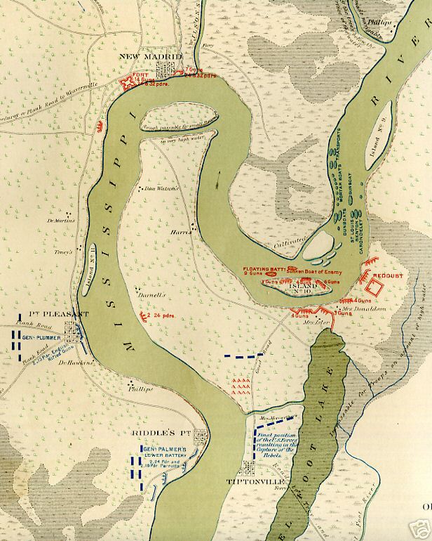
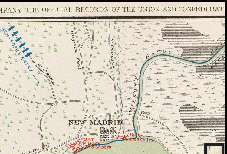
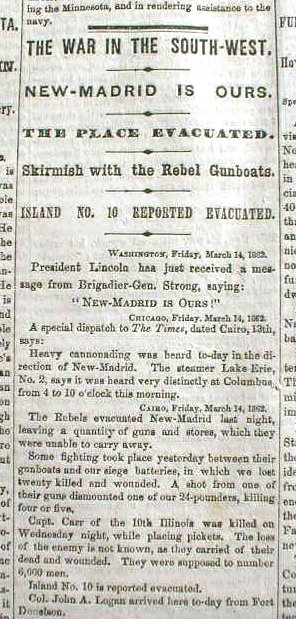
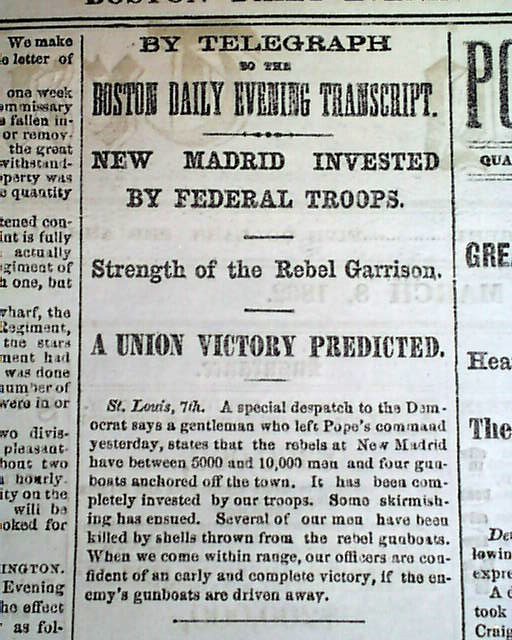
Above - General Pope's batteries at Point Pleasant Mo, South of New Madrid, dislodged. Enemy evacuated, leaving all his artillery, field batteries, tents, wagons, mules and an immense quantity of military stores. Brig. Gen Hamilton has occupied the place. This was the last stronghold of the enemy in this state. No rebel flag is now flying in Missouri. Mar 15, 1862 Boston Evening Transcript.
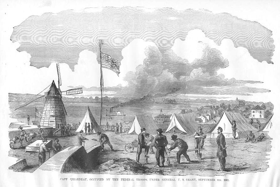
"Cape Girardeau, occupied by the Federal troops under General U.S. Grant, September 5th, 1861." Scene was published in "The Soldier in Our Civil War" 1885. Engraving appears to be a composite of scenes. River perspective could have been from Fort A, on a bluff just north of downtown. Two-story building with tower between center tents is likely Common Pleas Courthouse, which overlooks downtown. Multi-story building in top right may be St. Vincent's college, an academy to train Catholic priests for more than a century, now reworked, recently opened as part of the Southeast Mo. State University River Campus. Or it might supposedly represent the main Academic Hall of the then teacher's college.
Fort D, in the south part of town, would give a similar river perspective. Fort D's building still exists. Boat may be very realistic for the era. The boat is very similar to the "Red Rover" boat constructed in Cape Girardeau just before the Civil war, for the South, then captured near New Madrid by the North, which used it as a hospital ship, bringing wounded of both sides back to Mound City, IL (just north of Cairo, on the Ohio River) for care. Another fort in Cape was at the present University Academic Hall. The only local battle was in a field which now has the city's middle school and junior high.
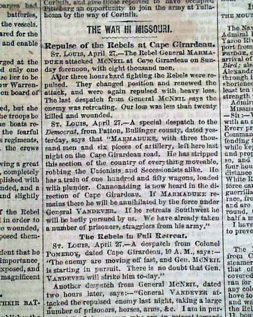
THE PHILADELPHIA INQUIRER, Pennsylvania, April 28, 1863.
Battle of Cape Girardeau - April 28, 1863 Wikipedia. Good bkg.
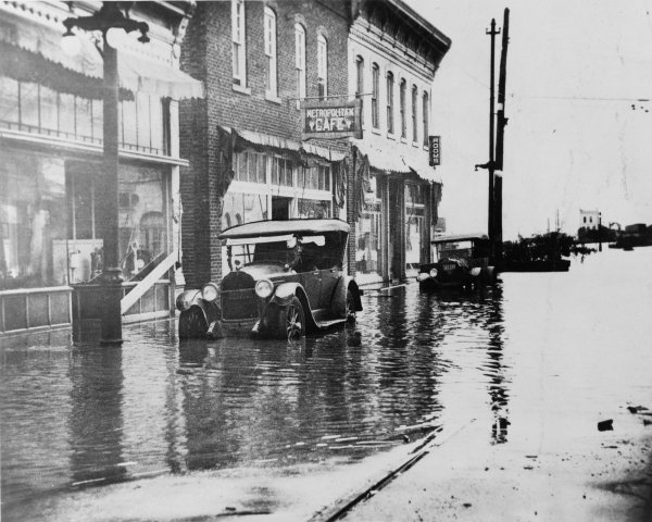
Above pic is the Cape Girardeau riverfront, pre-floodwall. Port Cape Girardeau restaurant is in the building with the 5c Coca Cola and furniture sign. General Grant's regional Civil War office was maybe upstairs for a few days, before he took command at Cairo. The Coke sign has been restored and remains. How in the world did the train engineer trust that the tracks had not been washed out?
We've borrowed some local newspaper text about that building:
Its most famous sign, the Coca-Cola advertisement on the north wall of the corner building, was restored through a joint effort by previous owner David Knight and the Coca-Cola Co. The original sign predates 1927. Knight's reason for that date is that before restoration, he said the phrase "fights fatigue" was still faintly visible on the ad. That phrase dates back to when the soft drink still contained cocaine, which was then legal.
Although much of the history of the Warehouse Row District can be traced through deeds and abstracts, the most famous and infamous parts of the popular history surrounding the buildings aren't documented at all.
The most popular legend regarding the buildings says that Gen. Ulysses S. Grant used them as his office and headquarters while stationed on the western front of the Civil War. However, Foley's recent discovery of the erection of the buildings being in the early 1860s doesn't give that tale much time for truth, since Grant was already head of the Union Army in the east by 1864.
The dating of the building also puts strain on another belief that the buildings were used as a stop for escaping slaves on the "underground railroad."
When Knight bought the building in 1974, it had been abandoned about 10 years. While cleaning and renovating the interior, he came upon a false wall in the rear of the corner building. The false wall led to an 8-by-8 enclosure, with no doors or windows. Knight said it is believed that due to the enclosure's proximity to a basement walkway that leads out to Main Street, it may have been a hiding spot for slaves seeking freedom. However, slavery was abolished in 1863, and by 1865, the underground railroad was seldom used.
Another of Knight's finds during renovation that probably holds a bit more historical truth is the discovery of about 40 cases of empty whiskey bottles hidden in the rafters on the third floor. It is thought that the district was home to a brothel or a speak-easy, where bootleg liquor was sold and served during Prohibition.
The Ghost of Port Cape
The legend that has recruited the most contemporary believers among employees of businesses within the district is that of a ghost.
Current owner Dean "Doc" Cain said he has had a number of bartenders, managers and waiters say they've heard strange noises in the still halls of Port Cape after hours. Cain himself said he's found lights on that he was sure had been turned off and light bulbs left unscrewed with no good explanation why.
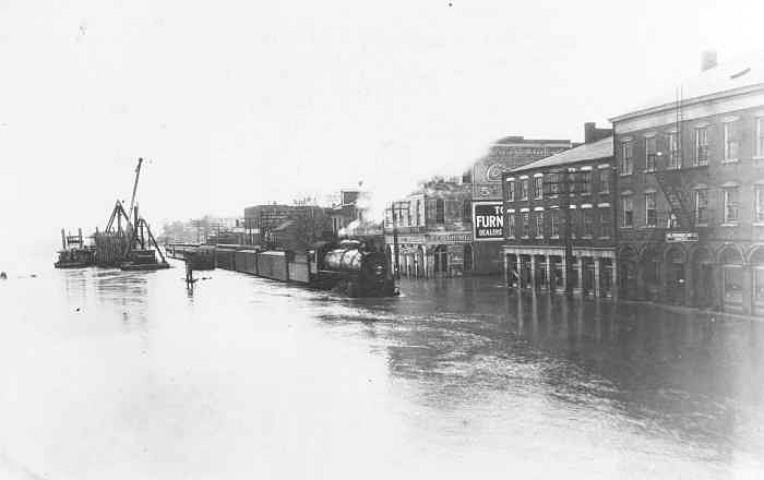
Cape Girardeau Riverfront - 1927 flood
|
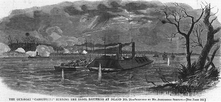
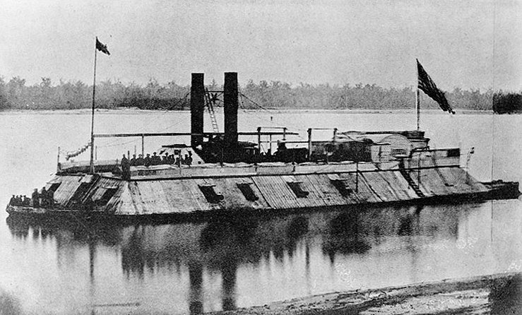
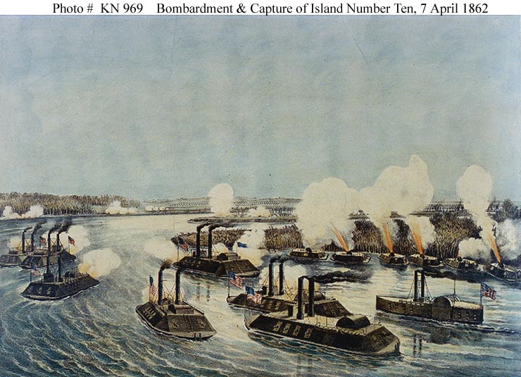
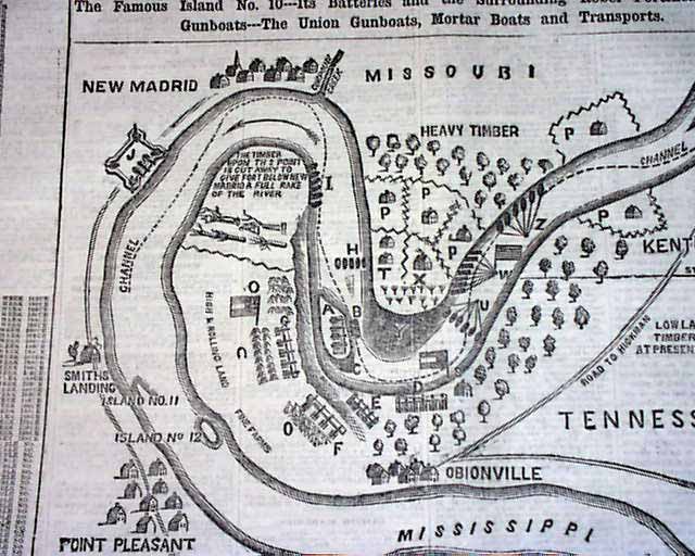
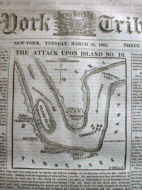
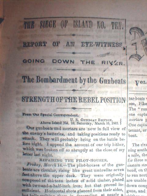
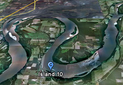
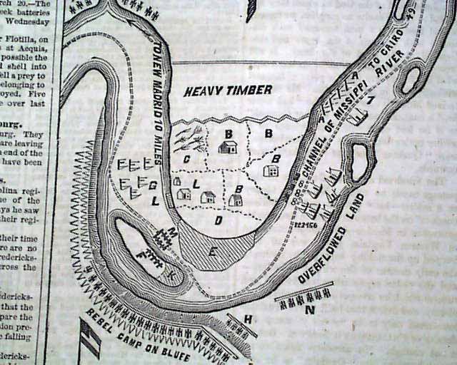
 Tennessee River. The Confederate troops return to Columbus.
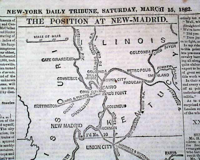
 however, one had to hunt for it with a spy-glass. Nothing was
left of it but an insignificant little tuft, and this was no longer near the
Kentucky shore; it was clear over against the opposite shore, a mile away.
however, one had to hunt for it with a spy-glass. Nothing was
left of it but an insignificant little tuft, and this was no longer near the
Kentucky shore; it was clear over against the opposite shore, a mile away.