New Madrid Seismic Zone graphics, illustrations, diagrams

Map pages 1 | 2 | 3 | 4 | 5 | 6 | 7 | aerials | sitemap


Above courtesy St. Louis Riverfront Times 2012
 

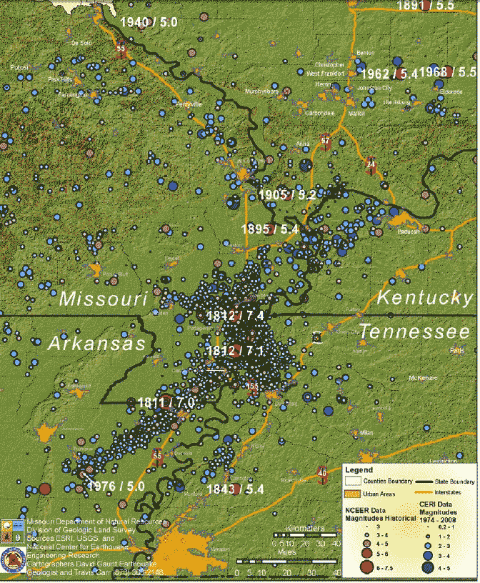
from Eugene Schweig 2007


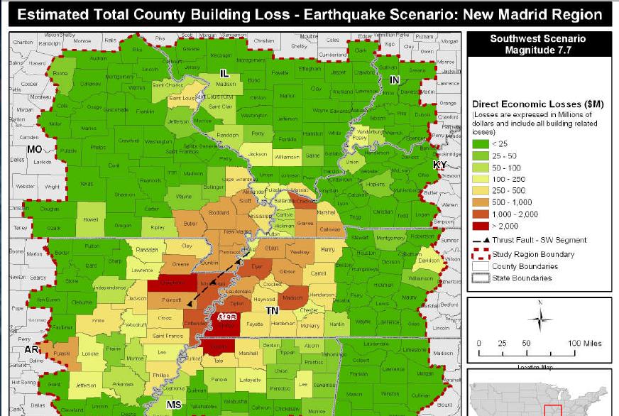
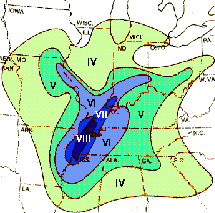
from Mo Gov Insurance Task Force Dec 2008 (click pic)


from http://scienceblogs.com/greengabbro/2008/04/earthquake_in_illinois_whats_u.php


Scenario of a big shake in NE section of NM fault

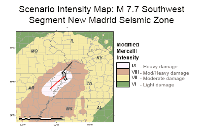
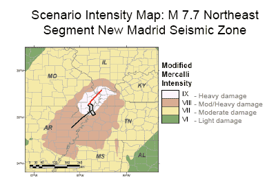
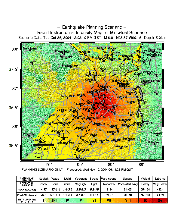
Scenarios from EPA - PDF slideshow

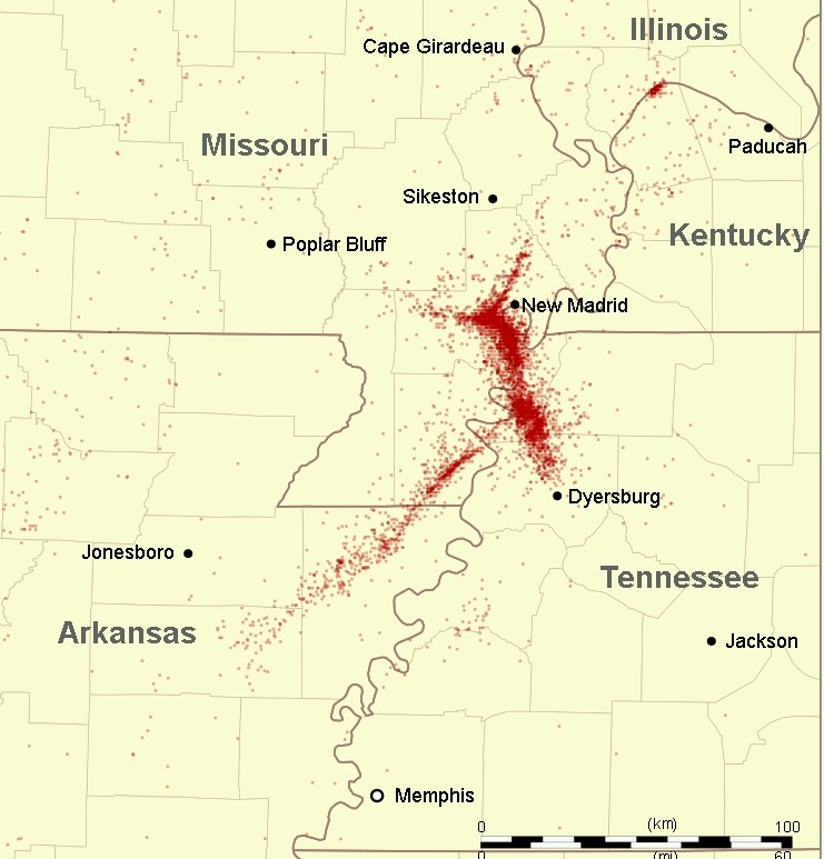
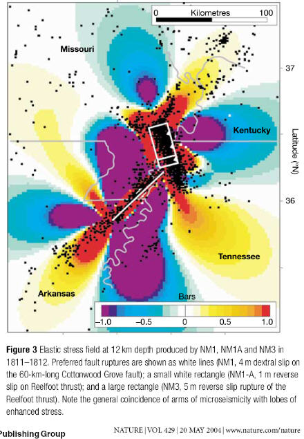
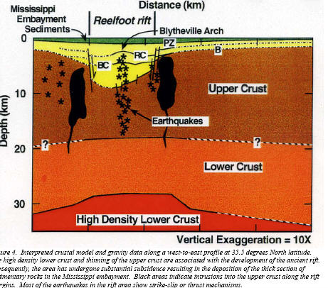
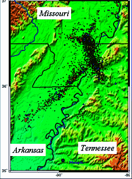
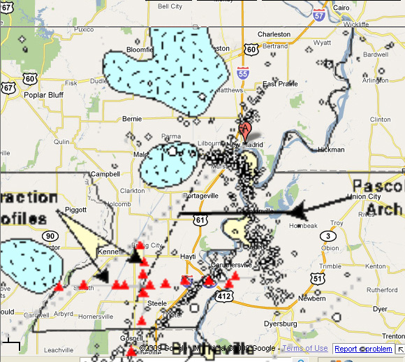
Above is a computer-generated plot (black dots) of recent quakes below ground... showing Reelfoot Fault. Seismologist Roy Van Arsdale provided this video to the History Channel.

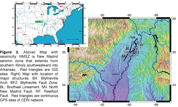
Paper: Characterization of Active Faults in NMSZ / Van Arsdale / Ellis / 40page PDF UIUC

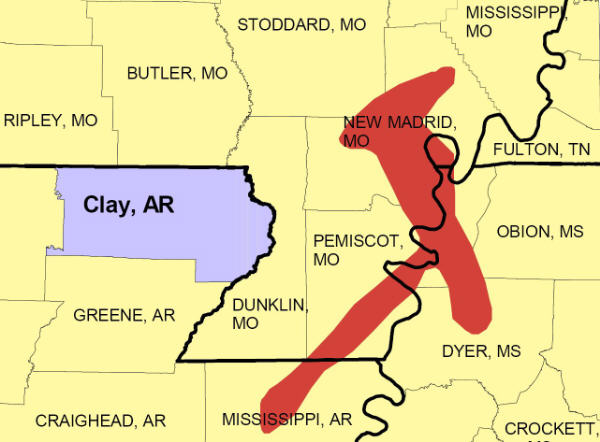
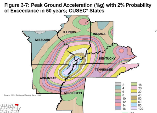
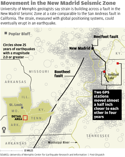
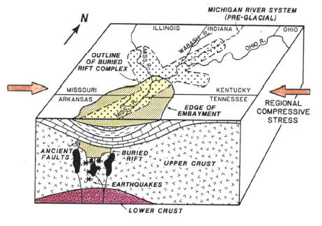
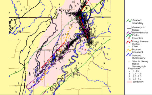
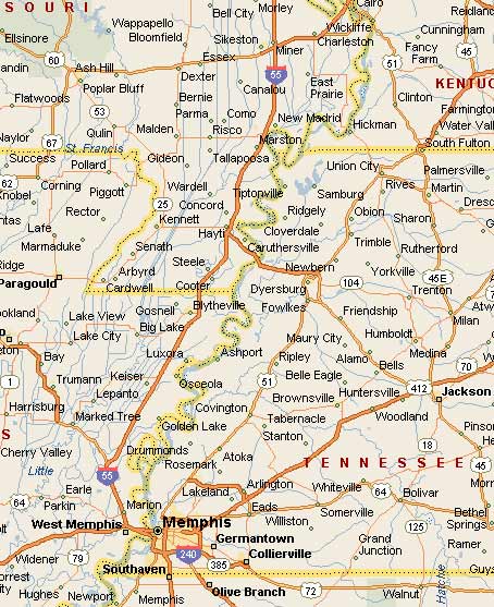
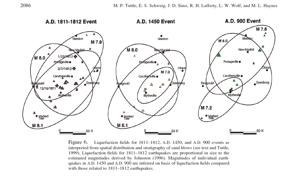
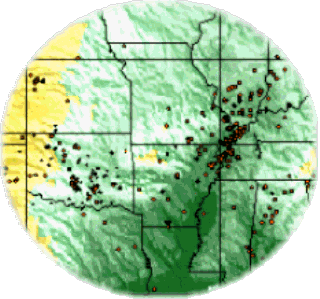
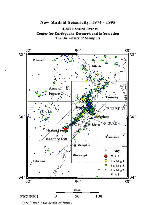
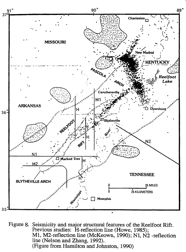
The New Madrid fault system, or the New Madrid seismic zone, is a series of faults beneath the continental crust in a weak spot known as the Reelfoot Rift. It cannot be seen on the surface. The fault system extends 150 miles southward from Cairo, Illinois through New Madrid and Caruthersville, Missouri, down through Blytheville, Arkansas to Marked Tree, Arkansas. It dips into Kentucky near Fulton and into Tennessee near Reelfoot Lake, and extends southeast to Dyersburg, Tennessee. It crosses five state lines, and crosses the Mississippi River in at least three places. CERI

USGS map

Digital Tectonic Activity Map (DTAM)

...says city administrator Furgison Hunter, "If something real would happen here, we already store water and tell people to turn their gas off." 

H.H. "Buddy" Townsend, who runs an insurance agency on Main Street, recalls waking up in the night as a young man, with earthquakes sounding like a herd of buffalo running outside his window. Recently, he was cleaning out a shed and found an earthquake survival kit dating back to the 1990 scare. "The kit still had water," he says. "What it tasted like, I don't know. But, really, we don't worry about this. We were raised with earthquakes." 
  - USA Weekend, Sept 3, 2004

Researcher Martitia Tuttle's NM graphics - click

good pdf map of NM fault zone & major 1811-12 shakes


Map pages 1 | 2 | 3 | 4 | 5 | 6 | aerials | sitemap

Elastic stress on New Madrid area: USGS


new madrid fault moving

Felt Map earthquake New Madrid Dec 16 1811 8 a.m.

Felt map Jan 1812 earthquake New Madrid: USGS

eas.slu cross-section New Madrid fault

http://www.eas.purdue.edu/~braile/news/midwest.pdf

http://quake.ualr.edu Hazard Mitigation

Time line New Madrid Fault


Map pages 1 | 2 | 3 | 4 | 5 | 6 | 7 | aerials | sitemap

map Memphis-Cairo mapblast

New Madrid seismic zone

Elevation: Purple 47 m., to orange, 360 m.- USGS.


http://www.eas.purdue.edu/~braile/news/nmmap.pdf

Map pages 1 | 2 | 3 | 4 | 5 | 6 | 7 | aerials | sitemap

New Madrid fault 900 1450 1811 compared

Memphis area earthquake planning

http://www.seismo.unr.edu/ftp/pub/louie/class/100/seismic-waves.html

P waves arrive before S waves. Naturalist John James Audubon was traveling in central Kentucky when he felt a quake and describes each:

I had proceeded about a mile, when I heard what I imagined to be the distant rumbling of a violent tornado, on which I spurred my steed, with a wish to gallop as fast as possible to the place of shelter; but it would not do, the animal knew better than I what was forthcoming, and, instead of going faster, so nearly stopped, that I remarked he placed one foot after another on the ground with as much precaution as if walking on a smooth sheet of ice.I thought he had suddenly foundered, and, speaking to him, was on the point of dismounting and leading him, when he all of a sudden fell a-groaning piteously, hung his head, spread out his four legs, as if to save himself from falling, and stood stock still, continuing to groan.

I thought my horse was about to die, and would have sprung from his back had a minute more elapsed, but at that instant all the shrubs and trees began to move from their very roots, the ground rose and fell in successive furrows, like the ruffled waters of a lake, and I became bewildered in my ideas, as I too plainly discovered that all this awful commotion in nature was the result of an earthquake.

20 yr Midwest quakes

Pattern of quakes in last 20 years: USGS


New Madrid zone seismicity: CERI

Roman numerals indicate estimated Modified Mercalli intensities for a 6.5 magnitude earthquake. Based on maps in W. Atkinson, 1989, The Next New Madrid Earthquake, Southern Illinois University Press


New Madrid seismicity

Reelfoot Rift - New Madrid quakes mapped


Shows plutons and epicenters in relation to present day cities. Ignore red triangles.
The area east of Bloomfield was a swamp in Civil War days. The pluton there likely was part of the cause.

strike slip illustration

New Madrid Seismic Zone graphics, illustrations, diagrams

PDF graphics - 4

More graphics  4 | 5 | 6 | 7

Central US quake hazards maps USGS PDF GIF

Calif survival handbook (many photos, graphics, tips)

Southeast Missouri earthquake hazard map - MO DNR

San Andreas fault, at surface, rough-looking

Point Pleasant, south of New Madrid, was washed down the river by one of the main 1811-12 quakes. It was rebuilt nearby, and saw Civil War action. Illustration | map

Topo map of Commerce, English Hills, Thebes Gap, Cache River

Mississippi Embayment (reached to just north of Cairo), NMSZ topography.

Sand boils in NMSZ | NM river bend aerial photo showing location of Mississippi River running backwards

Map pages 1 | 2 | 3 | 4 | 5 | 6 | 7 | aerials


Quake sitemap


Powered by Show-Me.net